
What are the Positive Aspects of Drone Technology in Agriculture, Construction, Mapping and Asset Inspection?
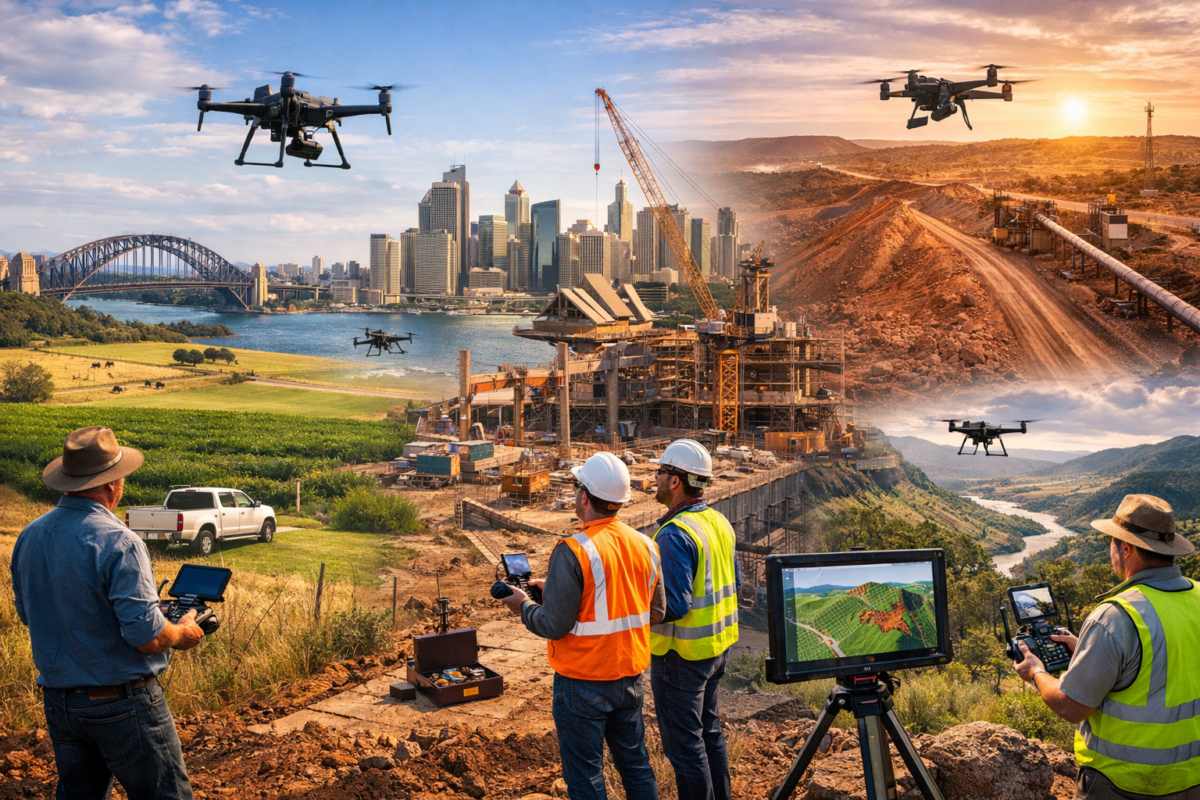
The Australian landscape is vast, diverse, and often challenging to monitor and manage using traditional methods. From sprawling agricultural properties in regional Queensland to complex construction sites in Sydney and from critical infrastructure inspections across remote Western Australia. To detailed surveying projects in Victoria, drone technology is revolutionising how Australian businesses operate across multiple sectors.
Unmanned Aerial Vehicles (UAVs), commonly known as drones, have evolved from novelty gadgets to essential business tools that deliver measurable returns on investment. The Australian drone market is experiencing explosive growth, with the agriculture drone sector alone expected to reach US$578.4 million by 2034, exhibiting a remarkable compound annual growth rate (CAGR) of 25.79%. Meanwhile, the construction industry stands to save between $1.8 and $4.3 billion between 2020 and 2040 through drone adoption.
But what makes drone technology so transformative? Beyond the impressive statistics, drones are fundamentally changing how Australian businesses approach agriculture, construction, mapping, and asset inspection. They’re enabling farmers to manage water resources more effectively during droughts, helping construction managers identify safety hazards before accidents occur, allowing surveyors to complete in days what once took weeks, and permitting inspectors to assess dangerous infrastructure without putting lives at risk.
This article explores the positive aspects of drone technology across these four critical sectors, providing Australian business owners and decision-makers with the insights needed to understand why drones are becoming indispensable tools in the modern Australian economy.
1. Significant Cost Savings and Efficiency Gains
One of the most compelling advantages of drone technology is its ability to deliver substantial cost reductions whilst simultaneously improving operational efficiency across all sectors.
Agriculture
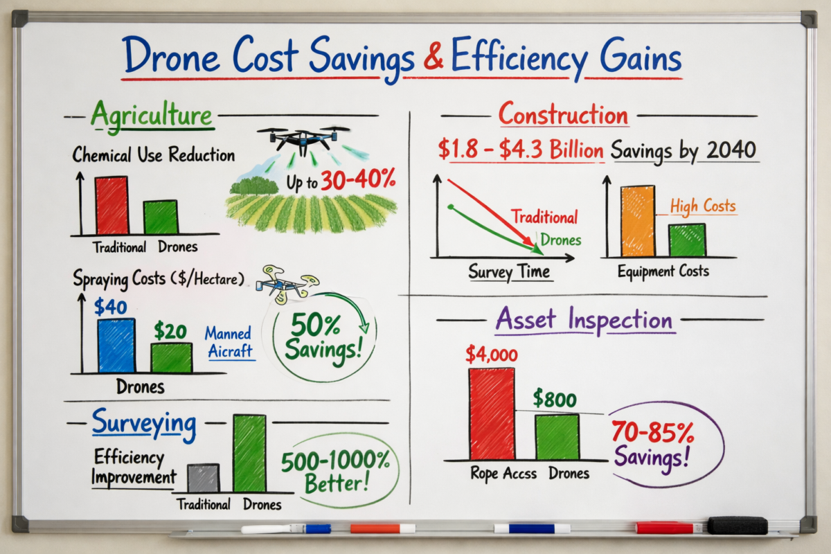
In Australian agriculture, where input costs continue to rise and profit margins remain tight, drones are delivering game-changing savings. Chemical inputs represent one of the largest cost pressures for farmers, and drone technology addresses this directly through precision application. Rather than blanket-spraying entire fields, agricultural drones equipped with multispectral cameras can identify exactly which areas require treatment, reducing pesticide and fertiliser usage by up to 30-40%.
A wheat farmer in the Riverina region, for example, can use drones to map crop health across thousands of hectares, identifying stressed areas that require attention whilst avoiding unnecessary treatment of healthy crops. This targeted approach not only reduces chemical costs but also minimises waste and environmental impact.
Drones also eliminate the need for expensive manned aircraft for crop spraying operations. Traditional aerial spraying can cost $30-50 per hectare, whilst drone spraying operations can reduce this to $15-25 per hectare, representing savings of up to 50% on large properties.
Construction
The construction sector is experiencing even more dramatic cost benefits. According to industry analysis, Australian construction companies can expect savings of $1.8 to $4.3 billion between 2020 and 2040 through drone adoption. These savings come from multiple sources:
Reduced rework costs: Drones provide regular, detailed site documentation that helps identify errors early. When a Brisbane high-rise project discovers a foundation misalignment during the excavation phase rather than after concrete is poured, the savings can run into hundreds of thousands of dollars.
Faster surveying: Traditional surveying methods might take a team of surveyors several days to map a large construction site. A drone can complete the same task in hours, reducing labour costs by 70-80% whilst providing more comprehensive data.
Equipment optimisation: Real-time aerial monitoring helps construction managers track equipment utilisation, ensuring machinery isn’t sitting idle and reducing unnecessary rental costs.
Mapping and Surveying
Professional surveying firms are experiencing efficiency gains of 500-1000% compared to traditional methods. A mining survey in the Pilbara that might have required a team of surveyors working for two weeks can now be completed by a two-person drone team in two days, with more accurate results and comprehensive 3D mapping data.
Asset Inspection
Asset inspection costs drop dramatically when drones replace traditional methods. Inspecting a telecommunications tower that would require hiring specialised rope access technicians at $2,000-5,000 per day can be completed with a drone inspection for $500-1,500, representing savings of 70-85%. When multiplied across hundreds or thousands of assets, these savings become transformational for infrastructure managers.
2. Enhanced Safety and Dramatic Risk Reduction
Safety improvements represent perhaps the most valuable benefit of drone technology, as they protect human lives whilst simultaneously reducing liability and insurance costs.
Construction
Construction remains one of Australia’s most dangerous industries, with falls from height accounting for a significant proportion of workplace fatalities. Drones eliminate the need for workers to access dangerous areas for inspection and monitoring purposes.
Instead of sending workers onto partially completed roofing structures, scaffolding, or high-rise floors to assess progress or identify issues, construction managers can deploy drones to capture detailed imagery and video. This approach has proven particularly valuable on major Australian projects like the Sydney Metro construction, where drones monitor progress across multiple sites without exposing workers to unnecessary risks.
Drones also excel at identifying safety hazards before they cause accidents. Thermal imaging drones can detect electrical faults, structural weaknesses, or water ingress that might not be visible to the naked eye, allowing remediation before incidents occur.
Asset Inspection
The safety benefits in asset inspection are even more pronounced. Traditional inspection methods for infrastructure like:
- High-voltage transmission towers
- Wind turbines
- Telecommunications masts
- Bridge structures
- Industrial chimneys and flare stacks
- Offshore oil and gas platforms
All require workers to access dangerous heights or hazardous environments. Each inspection carries inherent risks of falls, electrical hazards, or exposure to toxic substances.
Drones eliminate these risks entirely. An inspector can thoroughly examine a 60-metre telecommunications tower from the safety of the ground, capturing high-resolution imagery that reveals corrosion, structural damage, or equipment faults without anyone leaving terra firma. For inspections of confined spaces like tanks, silos, or pipelines, drones equipped with specialised sensors can enter environments that would be immediately dangerous to human life.
Agriculture
In agriculture, drones reduce the need for farmers to personally inspect remote or dangerous areas of their properties. Checking water levels in dams, assessing fence lines in rough terrain, or monitoring livestock in areas with dangerous wildlife can all be accomplished safely via drone, reducing the risk of vehicle accidents, snake bites, or other rural hazards.
The reduction in manned aircraft operations for crop spraying also improves safety, as agricultural aviation has historically been one of the higher-risk aviation sectors.
3. Environmental Benefits and Sustainability Outcomes
As Australian businesses face increasing pressure to demonstrate environmental responsibility and meet sustainability targets, drones are emerging as powerful tools for reducing environmental impact.
Agriculture
The environmental benefits in agriculture are particularly impressive. According to industry research, the implementation of agricultural drones has significantly decreased carbon emissions by 25.72 million metric tons globally, with Australian agriculture contributing to this reduction.
This emissions reduction comes from several sources:
Precision application: By applying pesticides, herbicides, and fertilisers only where needed, drones prevent chemical runoff into waterways and reduce the total volume of chemicals entering the environment. This is particularly important in areas near the Great Barrier Reef, where agricultural runoff has been identified as a significant environmental concern.
Reduced fuel consumption: Drone operations consume a fraction of the fuel required for traditional tractor-based spraying or manned aircraft operations. A drone spraying operation might use 2-3 litres of fuel per day compared to 50-100 litres for a tractor covering the same area.
Water conservation: In drought-prone Australia, drones equipped with thermal and multispectral sensors can identify areas of water stress, allowing farmers to apply irrigation precisely where needed rather than watering entire fields. This targeted approach can reduce water usage by 20-30% whilst maintaining or improving crop yields.
Soil health preservation: Drones eliminate the need for heavy machinery to traverse fields repeatedly, reducing soil compaction that can damage soil structure and reduce long-term productivity.
Construction
Construction sites generate significant environmental impacts, but drones help minimise these effects:
Reduced vehicle movements: Accurate drone surveying reduces the need for multiple site visits by different teams, cutting vehicle emissions and traffic congestion around construction sites.
Waste reduction: Better monitoring and documentation reduce errors and rework, which in turn reduces construction waste. When a Melbourne apartment project identifies a design conflict before materials are ordered and installed, it prevents tonnes of waste from reaching landfill.
Dust and erosion monitoring: Drones can monitor dust levels and erosion on construction sites, helping managers implement controls that protect local air and water quality.
Mapping and Asset Inspection
Environmental monitoring itself becomes more effective with drones. They can track vegetation health, monitor coastal erosion, assess environmental remediation projects, and document compliance with environmental regulations—all without the environmental impact of traditional monitoring methods that might require vehicles, boats, or aircraft.
4. Labour Cost Reduction and Workforce Optimisation
Australia’s tight labour market and high wage costs make workforce efficiency a critical concern for businesses. Drones address this challenge by automating tasks that would otherwise require significant manual labour.
Agriculture
Australian agriculture faces chronic labour shortages, particularly in regional and remote areas. Drones help address this challenge by automating monitoring and application tasks that would traditionally require multiple workers.
A single drone operator can monitor crop health across thousands of hectares in a day—work that might require a team of agronomists walking fields for weeks. Similarly, drone spraying operations typically require 2-3 operators compared to the larger crews needed for traditional ground-based spraying.
This labour efficiency is particularly valuable during peak seasons when finding additional workers is difficult and expensive. During harvest season, drones can provide rapid crop assessments that help farmers optimise harvest timing and logistics without pulling workers away from harvesting operations.
Construction
Construction labour costs in Australia are among the highest in the world, making efficiency improvements particularly valuable. Drones reduce labour requirements in several ways:
Surveying efficiency: A two-person drone team can complete surveying work that might otherwise require a four-person traditional surveying crew, reducing labour costs by 50% whilst completing the work faster.
Progress monitoring: Rather than having project managers and supervisors spend hours walking sites to assess progress, drones can capture comprehensive site documentation in 20-30 minutes, freeing these highly-paid professionals to focus on decision-making and problem-solving.
Reduced inspection time: Building inspectors can use drone footage to conduct preliminary assessments, reducing the time required for on-site inspections and allowing them to focus their site time on areas that require detailed examination.
Asset Inspection
The labour savings in asset inspection are dramatic. Traditional tower inspections might require a team of three rope access technicians working for a full day. A drone inspection can be completed by a single operator in 1-2 hours, representing a labour reduction of over 90%.
For organisations managing large asset portfolios—telecommunications companies with thousands of towers, electricity distributors with extensive transmission networks, or mining companies with vast infrastructure—these labour savings multiply into millions of dollars annually.
5. Superior Data Accuracy and Enhanced Decision-Making
The quality and comprehensiveness of data captured by drones surpasses traditional methods in many applications, leading to better-informed decisions and improved outcomes.
Agriculture
Modern agricultural drones equipped with multispectral and thermal imaging sensors capture data that’s simply invisible to the human eye. These sensors can detect:
Early crop stress: Multispectral imaging identifies plant stress 7-10 days before it becomes visible to the naked eye, allowing farmers to intervene before yield losses occur.
Precise plant counts: Automated image analysis can count individual plants across entire fields, providing accurate population data that informs replanting decisions and yield predictions.
Soil variation mapping: Thermal and multispectral data reveals soil composition variations that affect crop performance, enabling variable-rate application of inputs tailored to specific soil conditions.
Pest and disease detection: Drones can identify the thermal and spectral signatures of pest infestations or disease outbreaks, allowing targeted treatment before problems spread.
This data accuracy translates directly into better decisions. A cotton farmer in northern New South Wales can use drone data to create precise irrigation maps that deliver exactly the right amount of water to each zone of a field, optimising yield whilst minimising water usage—critical in Australia’s variable climate.
Construction
In construction, data accuracy prevents costly errors and disputes:
Volumetric calculations: Drone photogrammetry provides accurate measurements of earthwork volumes, stockpile quantities, and material usage. These measurements are typically accurate to within 1-2%, compared to 5-10% accuracy for traditional estimation methods.
As-built documentation: Regular drone surveys create a comprehensive visual record of construction progress. When disputes arise about what work was completed when, this documentation provides objective evidence that can save hundreds of thousands of dollars in legal costs.
Quality control: High-resolution drone imagery can identify quality issues like concrete finishing problems, alignment errors, or material defects that might be missed during ground-level inspections.
Mapping and Surveying
Surveying accuracy is fundamental to project success, and drones deliver exceptional precision. Modern drone surveying systems can achieve horizontal accuracy of 2-3 centimetres and vertical accuracy of 5-6 centimetres when using ground control points—accuracy that meets or exceeds requirements for most engineering and construction applications.
The comprehensive nature of drone data is equally important. Rather than capturing measurements at specific points, drones create complete 3D models of entire sites, providing context and detail that point-based surveying cannot match.
Asset Inspection
Drone inspections capture far more comprehensive data than traditional methods. A rope access technician inspecting a tower might take 50-100 photographs of specific areas. A drone inspection might capture 500-1,000 images covering every surface of the structure, ensuring nothing is missed.
Advanced sensors add further capability. Thermal imaging can detect hot spots in electrical equipment, moisture ingress in building envelopes, or insulation defects in industrial facilities—problems that would be invisible during visual inspections.
6. Operational Speed and Real-Time Insights
The speed at which drones can capture and deliver data creates opportunities for more responsive, agile operations across all sectors.
Agriculture
Agricultural decision-making often operates on tight timeframes. When a pest outbreak occurs, every day of delay in treatment allows the problem to spread and worsen. Drones enable rapid response:
A farmer who notices potential pest activity can deploy a drone to survey the entire property within hours, identify the extent of the problem, and begin targeted treatment the same day. Traditional scouting methods might take days to assess the full extent of an outbreak, by which time significant damage has occurred.
Similarly, weather-dependent decisions benefit from rapid drone assessment. Before applying expensive inputs ahead of forecast rain, a farmer can quickly verify crop conditions across the entire property, ensuring resources are deployed where they’ll deliver maximum benefit.
Construction
Construction projects operate on strict schedules where delays cascade into cost overruns. Drones enable rapid response to emerging issues:
Daily progress monitoring: Rather than waiting for weekly progress meetings to identify delays, project managers can review daily drone footage to spot problems immediately and implement corrective actions before delays compound.
Rapid problem-solving: When issues arise—a delivery of incorrect materials, a subcontractor working in the wrong location, or a safety hazard—drones can quickly document the situation, providing all stakeholders with a common understanding that accelerates resolution.
Client updates: Drones enable construction companies to provide clients with current site imagery within hours of a request, improving client satisfaction and reducing the time project managers spend preparing progress reports.
Mapping and Surveying
Survey speed directly impacts project timelines. A mining company planning an expansion can receive survey data within days rather than weeks, accelerating engineering design and regulatory approvals. This speed advantage can bring projects online months earlier, delivering revenue sooner and improving return on investment.
Asset Inspection
For critical infrastructure, inspection speed can be the difference between planned maintenance and emergency repairs. A drone can inspect an entire substation in hours, identifying developing problems that can be addressed during scheduled maintenance rather than waiting until equipment fails and causes costly unplanned outages.
Why These Benefits Matter for Australian Businesses
The positive aspects of drone technology outlined above aren’t merely theoretical advantages—they’re delivering measurable value to Australian businesses today. From family farms in regional areas to major construction companies working on billion-dollar infrastructure projects, drones are proving their worth through improved safety, reduced costs, better environmental outcomes, and enhanced decision-making.
As the Australian drone market continues its rapid growth trajectory, early adopters are establishing competitive advantages that will be difficult for late movers to overcome. Farmers using drone technology are achieving better yields with fewer inputs. Construction companies leveraging drones are winning contracts by demonstrating superior project management capabilities. Asset owners using drone inspections are reducing maintenance costs whilst improving safety and reliability.
Understanding these benefits is the first step toward evaluating whether drone technology makes sense for your operation. The next step is understanding the regulatory framework that governs drone operations in Australia, the specific applications relevant to your industry, and the practical considerations involved in implementing drone programs—topics we’ll explore in upcoming articles.
For Australian businesses operating in agriculture, construction, mapping, or asset inspection, the question is no longer whether to adopt drone technology, but how quickly you can implement it to capture the substantial benefits it offers.
Frequently Asked Questions
Q: How much can I realistically expect to save by implementing drone technology in my business?
A: Savings vary significantly by industry and application, but documented examples include:
- Agriculture: 30-40% reduction in chemical input costs, 50% reduction in aerial spraying costs
- Construction: Industry-wide savings of $1.8-4.3 billion projected between 2020-2040 in Australia
- Asset inspection: 70-85% cost reduction compared to traditional rope access or scaffolding methods
- Surveying: 70-80% reduction in labour costs with 500-1000% efficiency improvements
Most businesses report ROI within 6-18 months of implementation, though this depends on scale of operations and frequency of use.
Q: Are drones really safer than traditional methods, or is this just marketing?
A: The safety benefits are well-documented and substantial. Drones eliminate the need for workers to access heights, confined spaces, or hazardous environments for inspection and monitoring purposes. In construction, falls from height are a leading cause of workplace fatalities—drones remove this risk for many tasks. In asset inspection, drones eliminate risks associated with rope access, scaffolding, and working near high-voltage equipment. The safety benefits are real and measurable through reduced workplace incidents.
Q: What environmental benefits do drones actually provide?
A: Key environmental benefits include:
- Reduction of 25.72 million metric tons of carbon emissions globally through agricultural drone use
- 30-40% reduction in pesticide and fertiliser usage through precision application
- 20-30% reduction in water usage through targeted irrigation
- Reduced soil compaction from eliminating heavy machinery passes
- Lower fuel consumption compared to traditional methods
- Reduced chemical runoff into waterways
- Better environmental monitoring and compliance documentation
Q: Do I need to hire specialist drone operators, or can existing staff be trained?
A: Both options are viable. Many Australian businesses successfully train existing staff to obtain CASA operator accreditation and remote pilot licences. Training typically takes 2-4 weeks and costs $2,000-5,000. Alternatively, you can contract specialist drone service providers for specific projects. The best approach depends on your frequency of use—regular users typically benefit from in-house capability, whilst occasional users may prefer contractors.
Q: How accurate is drone data compared to traditional surveying methods?
A: Modern drone surveying systems achieve horizontal accuracy of 2-3 cm and vertical accuracy of 5-6 cm when using ground control points—accuracy that meets or exceeds requirements for most engineering and construction applications. For agriculture, drones provide more comprehensive data than traditional scouting methods. For asset inspection, high-resolution cameras capture detail that often exceeds what’s visible during manual inspections.
Q: What’s the typical return on investment timeline for drone technology?
A: Most Australian businesses report ROI within 6-18 months, depending on:
- Frequency of use (daily users see faster ROI than monthly users)
- Scale of operations (larger operations see faster ROI)
- Application type (some applications like asset inspection deliver faster returns than others)
- Whether you’re replacing expensive existing methods (replacing rope access inspections delivers faster ROI than adding new capability)
High-frequency users in construction and agriculture often achieve ROI within 3-6 months.
Q: Can drones operate in typical Australian weather conditions?
A: Modern commercial drones are designed to operate in a wide range of conditions, but do have limitations:
- Most can operate in light rain but not heavy precipitation
- Wind limits vary by drone model (typically 10-15 m/s for smaller drones, 15-20 m/s for larger models)
- Extreme heat (40°C+) may require operational modifications
- Dust and smoke can affect visibility and sensor performance
Australian drone operators develop strategies to work around weather limitations, such as scheduling flights during calmer morning conditions or using weather-resistant drone models for challenging environments.
Q: How does drone technology help with Australia’s specific challenges like drought and remote operations?
A: Drones are particularly valuable for Australian conditions:
- Drought management: Thermal and multispectral sensors identify water stress early, enabling targeted irrigation that conserves precious water resources
- Remote operations: Drones can monitor remote areas without requiring travel, reducing costs and vehicle emissions whilst providing more frequent monitoring
- Large property management: Drones can cover thousands of hectares quickly, making them ideal for Australia’s large agricultural properties
- Bushfire monitoring: Drones can assess fire damage, monitor fire risks, and support recovery efforts
- Infrastructure in remote areas: Drones can inspect remote infrastructure without requiring expensive mobilisation of inspection crews
Q: What ongoing costs should I budget for drone operations?
A: Typical ongoing costs include:
- Insurance: $1,500-5,000 annually depending on coverage and operations
- Maintenance and repairs: 5-10% of equipment cost annually
- Battery replacements: $200-500 per battery every 12-18 months
- Software subscriptions: $100-500 monthly for processing and analysis software
- Training updates and regulatory compliance: $500-1,500 annually
- Equipment upgrades: Budget for replacement every 3-5 years as technology advances
Q: Are the benefits of drone technology proven in Australian conditions, or are these international examples?
A: The benefits are well-documented in Australian conditions specifically. The $1.8-4.3 billion construction savings figure is based on Australian industry analysis. The agricultural drone market growth to USD 578.4 million by 2034 is specific to Australia. Australian companies across all sectors are reporting measurable benefits, from Queensland cane farmers reducing chemical costs to Victorian construction companies improving safety records to Western Australian mining companies reducing inspection costs. The technology is proven in Australian conditions and delivering results for Australian businesses today.