

North Queensland’s sugar cane industry stands as one of Australia’s most enduring agricultural success stories. Since the first commercial plantings in the 1860s, when pioneering settlers recognised the region’s extraordinary potential, sugar cane has woven itself into the economic and cultural fabric of tropical Queensland. Today, this industry generates over $2 billion annually for the Australian economy, employs more than 16,000 people directly and indirectly, and produces approximately 95% of Australia’s raw sugar—much of it destined for export markets across Asia and the Middle East.
The sugar belt stretches along an impressive 2,100-kilometer coastal corridor from Mossman in the far north, where cane fields press against the edge of the Daintree Rainforest, down through the fertile plains of the Burdekin, Herbert, and Tully regions, to the southern reaches near Mackay. This vast agricultural landscape encompasses roughly 380,000 hectares of cultivated land, where the combination of rich volcanic soils, consistent tropical rainfall averaging 1,200 to 4,000 millimetres annually, and year-round warmth creates near-perfect conditions for sugar cane cultivation. The region’s fields are a patchwork of green—from the bright, vibrant shoots of newly planted ratoon crops to the towering, mature cane standing four meters high, ready for harvest.
Yet beneath this verdant prosperity lies a complex web of challenges that have intensified dramatically over the past two decades. Managing such vast and diverse landscapes has never been simple, but contemporary pressures have transformed traditional difficulties into urgent imperatives demanding innovative solutions.
The Pest Management Dilemma
North Queensland’s tropical climate, while ideal for cane growth, also provides perfect breeding conditions for devastating pests. The cane grub (Dermolepida albohirtum), which can destroy up to 30% of a crop if left unchecked, burrows beneath the soil surface where it remains invisible until damage becomes catastrophic. Canegrub beetles, soldier flies, and the notorious yellow canopy syndrome—caused by the sugarcane aphid—can sweep through plantations with alarming speed. Traditional scouting methods require workers to physically walk fields, examining plants individually, a process that might cover only 2-3% of a large property and often detects problems only after significant damage has occurred. By the time visual symptoms appear at ground level, infestations may have already spread across dozens of hectares.
The reactive nature of conventional pest management means farmers often resort to blanket spraying—applying pesticides across entire fields as a precautionary measure rather than targeting specific problem areas. This approach is not only expensive, with chemical costs representing up to 15% of total production expenses, but also environmentally problematic and increasingly at odds with sustainability requirements from both regulators and international buyers.
Irrigation Complexity in a Variable Climate
Water management in North Queensland presents a paradox: the region experiences both flooding rains and periodic drought, sometimes within the same growing season. The variability of the Australian climate, exacerbated by El Niño and La Niña cycles, means that irrigation systems must be extraordinarily responsive. Some areas, like the Burdekin, rely heavily on irrigation infrastructure drawing from dams and river systems, while others depend on rainfall supplemented by strategic watering during dry spells.
The challenge lies in achieving uniformity across vast fields with varying topography, soil types, and drainage characteristics. Over-irrigation in low-lying areas leads to waterlogging, root disease, and nutrient leaching, while under-watered elevated sections produce stunted growth and reduced sugar content. Traditional irrigation scheduling relies on weather stations, soil moisture probes at fixed locations, and farmer intuition—a system that provides only a fragmentary picture of actual field conditions. A single 200-hectare block might contain dozens of micro-environments, each with different water requirements, yet conventional methods treat it as a uniform entity.
The Sustainability Imperative and Reef Crisis
Perhaps no challenge looms larger than the environmental impact of sugar cane farming on the Great Barrier Reef, located just offshore from much of the cane-growing region. Scientific research has established an undeniable link between agricultural runoff and reef degradation. Excess nitrogen and phosphorus from fertilisers, along with pesticide residues, flow from cane fields into river systems during the wet season, eventually reaching the reef lagoon. These nutrients fuel algal blooms that smother coral, reduce water clarity, and disrupt the delicate ecological balance that sustains the world’s largest living structure.
The numbers are sobering: agriculture contributes approximately 80% of the nitrogen entering the Great Barrier Reef lagoon, with sugar cane farming responsible for a significant portion of that load. The Australian and Queensland governments have established ambitious targets—reducing nitrogen runoff by 60% and pesticide loads by 60% by 2025—but achieving these goals while maintaining agricultural productivity has seemed nearly impossible using traditional farming methods.
International markets are also demanding change. Major food and beverage companies are implementing strict sustainability criteria for their supply chains, and Australian sugar must meet these standards to remain competitive. The industry faces a stark choice: innovate toward sustainability or risk losing access to premium markets worth hundreds of millions of dollars annually.
The labour and Economic Squeeze
Compounding these environmental and agronomic challenges is an economic reality that affects all of Australian agriculture: rising labour costs, workforce shortages, and pressure on profit margins. The average age of Australian farmers continues to climb—now over 56 years—and attracting young people to agricultural careers grows more difficult each year. Manual field scouting, equipment operation, and crop monitoring are labour-intensive activities that are becoming increasingly expensive and difficult to staff, particularly during peak seasons.
Meanwhile, global sugar prices remain volatile, and Australian producers face competition from lower-cost regions. The only sustainable path forward involves producing more with less—fewer inputs, less labour, reduced environmental impact—while maintaining or improving quality and yield.
Enter the Innovation Imperative
It is against this backdrop of mounting pressures that drone technology has emerged not as a luxury or experimental novelty, but as an essential tool for the industry’s survival and evolution. What began five years ago as tentative trials by a handful of progressive growers has accelerated into widespread adoption, driven by proven results and urgent necessity.
Drones represent more than just another piece of farm equipment—they embody a fundamental shift in how farmers understand and interact with their land. For the first time, growers can see their entire operation from above, in extraordinary detail, updated continuously throughout the growing season. They can detect problems invisible from ground level, apply inputs with surgical precision, and make data-driven decisions that balance productivity with environmental stewardship.
This transformation is reshaping North Queensland’s sugar cane industry from the ground up—or more accurately, from the sky down. The following exploration reveals how drone technology is addressing each of the industry’s critical challenges, protecting the Great Barrier Reef, improving farm economics, and charting a course toward a sustainable future for one of Australia’s most important agricultural sectors.
🚁 The Rise of Drone Technology in Cane Farming
The journey of drones from military reconnaissance tools to agricultural workhorses represents one of the most remarkable technology transfers of the 21st century. While unmanned aerial vehicles have existed since the early 1900s, their application to farming began in earnest only in the 2010s, when several technological breakthroughs converged to make agricultural drones both practical and affordable.
From Aerial Photography to Precision Agriculture
The earliest agricultural use of aerial imagery dates back to the 1920s, when fixed-wing aircraft equipped with basic cameras began photographing farmland to assess crop conditions. By the 1980s, satellite imagery offered broader coverage, but at resolutions too coarse and costs too high for individual farmers. The real revolution began around 2010, when consumer drone technology—driven by smartphone component miniaturization—suddenly made sophisticated aerial platforms accessible to non-military users.
Early agricultural drones were essentially flying cameras, capturing standard RGB (red-green-blue) photographs that provided a bird’s-eye view of fields. While useful for spotting obvious problems like irrigation failures or large pest infestations, these systems offered little advantage over a farmer walking the field or driving a utility vehicle along access roads. The breakthrough came with the integration of multispectral and thermal sensors—technologies that could “see” what human eyes could not.
By 2015, companies like DJI, senseFly, and PrecisionHawk had developed agricultural-specific platforms combining GPS-guided autonomous flight, multispectral imaging, and cloud-based analytics. These systems could capture data across multiple light wavelengths, process it through sophisticated algorithms, and deliver actionable insights within hours. For North Queensland’s sugar cane industry, this timing proved fortuitous: environmental pressures regarding reef protection were intensifying, labour costs were rising, and the technology had matured just enough to be reliable under tropical field conditions.
Technical Evolution: Making Drones Viable for Sugar Cane
Modern agricultural drones deployed across North Queensland’s cane fields are engineering marvels purpose-built for demanding tropical conditions. The most common platforms fall into two categories: multirotor drones for detailed imaging and monitoring, and larger fixed-wing or hybrid models for spraying operations.
Imaging drones, typically quadcopters or hexacopters, feature flight times of 25-35 minutes per battery, covering 40-80 hectares in a single mission depending on altitude and overlap requirements. They carry payloads of 1-2 kilograms, which includes multispectral camera systems weighing 400-800 grams. These cameras simultaneously capture imagery in five to ten distinct wavelengths, including visible light (red, green, blue), near-infrared, and red-edge bands—each revealing different aspects of plant health and vigour.
Spraying drones represent a different engineering challenge entirely. These heavy-lift platforms, such as the DJI Agras T40 or XAG P100, can carry 40-50 litres of liquid payload, weigh up to 90 kilograms when fully loaded, and generate enough downwash to penetrate dense cane canopies. Their flight time under load is typically 10-15 minutes, but quick-swap battery systems allow continuous operation with minimal downtime. Equipped with precision atomizing nozzles, GPS positioning accurate to within 2-3 centimetres, and terrain-following radar, these machines can apply chemicals with extraordinary accuracy even across undulating terrain.
Aerial Mapping: Seeing the Invisible
The foundation of drone-assisted cane farming is aerial mapping using multispectral imagery. Unlike conventional photographs that capture only what human eyes perceive, multispectral sensors record how plants reflect and absorb different wavelengths of light—a signature that reveals their physiological condition.
The most widely used metric is the Normalized Difference Vegetation Index (NDVI), which compares near-infrared reflection (which healthy plants reflect strongly) to red light absorption (which chlorophyll absorbs for photosynthesis). The resulting values, ranging from -1 to +1, create colour-coded maps where vibrant green indicates vigorous growth, yellow suggests moderate stress, and red signals severe problems. A North Queensland cane grower can fly a 200-hectare block in 45 minutes and receive an NDVI map showing precisely which areas are underperforming—information that would take days to gather through ground scouting and would still miss subtle variations.
Beyond NDVI, advanced indices like NDRE (Normalized Difference Red Edge) detect chlorophyll content with greater sensitivity, while GNDVI (Green Normalized Difference Vegetation Index) excels at identifying nitrogen deficiency. Thermal imaging adds another dimension, revealing temperature variations that indicate water stress, root disease, or irrigation system failures. A healthy cane plant maintains cooler leaf temperatures through transpiration; stressed plants show elevated temperatures hours or even days before visible symptoms appear.
The practical value is transformative. Farmers can identify pest infestations when they’re still confined to a few hectares rather than discovering them after they’ve spread across entire blocks. Soil compaction from heavy machinery, invisible at ground level, appears clearly in vegetation maps as linear patterns of reduced vigour. Drainage problems, nutrient deficiencies, and even underground irrigation leaks become visible, allowing targeted intervention rather than costly field-wide treatments.
Precision Spraying: Surgical Application of Inputs
If aerial mapping provides the diagnosis, precision spraying delivers the cure—with unprecedented accuracy. Traditional ground-based spraying equipment, whether tractor-mounted booms or aerial application from manned aircraft, applies chemicals uniformly across entire fields. This approach is inherently wasteful: healthy areas receive unnecessary treatment, while problem zones might not receive enough.
Agricultural spray drones change this equation fundamentally. Equipped with atomizing nozzles that produce droplets of 100-300 microns (about the width of a human hair), these systems can apply fertilisers, pesticides, and herbicides exactly where needed. The drone’s downwash—the powerful air current from its rotors—drives spray droplets deep into the cane canopy, achieving penetration that ground equipment cannot match. This is particularly crucial for tall, dense sugar cane, where conventional sprayers often fail to reach lower leaves and stalks where pests and diseases frequently establish.
The efficiency gains are remarkable. A spray drone can treat 4-6 hectares per hour, operating in conditions where ground equipment would bog down or damage crops. More importantly, precision targeting reduces chemical usage by 30-50% compared to blanket application. When a farmer identifies a 5-hectare pest hotspot within a 100-hectare block, the drone treats only those 5 hectares—saving chemicals, reducing environmental impact, and cutting costs. The economic calculation is straightforward: if pesticide costs $80 per hectare for conventional application, precision spraying might use $40-50 worth of chemical while achieving superior results.
The technology also enables variable-rate application, adjusting spray volume based on real-time data. Areas with severe infestations receive higher concentrations, while lightly affected zones get minimal treatment. GPS guidance ensures complete coverage without gaps or overlaps, and flight logs provide documentation for regulatory compliance and sustainability certification programs—increasingly important for export markets.
Crop Health Monitoring: Early Detection and Intervention
The true power of drone technology emerges in continuous crop health monitoring throughout the growing season. Sugar cane in North Queensland follows an 12-18 month growth cycle from planting to harvest, with ratoon crops (regrowth from harvested stalks) producing for 3-5 years before replanting. During this extended period, numerous threats can compromise yield: yellow canopy syndrome, orange rust, smut, ratoon stunting disease, and various insect pests.
Multispectral monitoring detects these problems at their earliest stages. Yellow canopy syndrome, caused by sugarcane aphids, initially affects only scattered plants but can explode across entire fields within weeks. Drone imagery reveals the characteristic spectral signature—reduced near-infrared reflectance and altered red-edge response—when only 2-3% of plants show symptoms. This early warning allows farmers to deploy targeted treatments before economic damage occurs.
Thermal imaging proves particularly valuable for detecting water stress and root diseases. Pachymetra root rot, a fungal disease that devastates cane roots, causes affected plants to show elevated leaf temperatures 5-7 days before visible wilting appears. By the time a farmer notices wilting from ground level, the disease has typically spread to neighbouring plants. Thermal drone surveys identify the initial infection point when it’s still treatable, potentially saving 20-30 hectares from destruction.
The monitoring frequency makes the difference. While satellite imagery might update every 5-10 days (and often suffers from cloud cover in tropical regions), drones can survey fields weekly or even daily during critical growth stages. This temporal resolution captures rapid changes—a pest outbreak, sudden nutrient deficiency, or irrigation failure—allowing intervention within 24-48 hours rather than weeks.
Yield Estimation: Predicting the Harvest
Perhaps the most economically valuable application is yield estimation using machine learning analysis of drone imagery. Traditionally, cane farmers estimate yields through manual sampling: cutting and weighing cane from representative areas, then extrapolating across the entire field. This method is labour-intensive, samples only 0.1-0.5% of the crop, and provides results just weeks before harvest—too late for meaningful management decisions.
Drone-based yield estimation works differently. Machine learning algorithms, trained on thousands of images correlated with actual harvest data, analyse multispectral imagery to predict cane tonnage and sugar content. The models consider multiple factors: canopy density (measured through vegetation indices), plant height (derived from photogrammetric analysis), stalk diameter (estimated from high-resolution imagery), and historical yield patterns for specific field zones.
The accuracy is impressive: well-calibrated models predict final yields within 8-12% of actual harvest results, and they do so 2-3 months before cutting begins. This advance notice transforms logistics planning. Mills can schedule crushing operations more efficiently, reducing the costly delays that occur when actual deliveries don’t match expectations. Farmers can prioritise harvest sequences, cutting high-sugar blocks first to maximise returns. Financial planning improves dramatically when growers know, with reasonable confidence, that they’ll deliver 12,000 tonnes rather than the hoped-for 15,000 tonnes.
The economic value extends beyond the current season. Yield maps accumulated over multiple years reveal spatial patterns—which field zones consistently outperform or underperform—guiding long-term decisions about replanting, variety selection, and infrastructure investment.
Integration: A Unified Precision Agriculture System
The true transformation occurs when these applications work together as an integrated system rather than isolated tools. A typical workflow in North Queensland’s cane fields now follows this pattern:
- Early Season Mapping (weeks 4-8 after planting): Drones survey fields to assess germination uniformity and identify areas requiring replanting or additional fertiliser.
- Growth Stage Monitoring (months 3-8): Bi-weekly multispectral flights track crop development, detect emerging pest or disease issues, and guide precision fertiliser applications.
- Mid-Season Intervention (months 6-10): Thermal imaging identifies water stress, prompting irrigation adjustments. Pest hotspots receive targeted spray treatments within 48 hours of detection.
- Pre-Harvest Assessment (months 10-12): Yield estimation models predict harvest volumes, sugar content, and optimal cutting schedules.
- Post-Harvest Analysis: Imagery from the completed season feeds into machine learning models, improving prediction accuracy for future crops.
This integrated approach generates a continuous feedback loop where each data point improves subsequent decisions. Farmers develop detailed knowledge of their land’s micro-environments, understanding which zones need extra attention and which consistently perform well with minimal input.
The Rapid Transition: From Novelty to Necessity
The speed of drone adoption in North Queensland’s sugar industry—from experimental curiosity to essential tool in less than five years—reflects several converging factors. First, the technology matured rapidly; early systems were fragile and unreliable, but by 2018-2019, agricultural drones had become robust enough for daily field use. Second, the economic case became undeniable: farmers who adopted drones early reported chemical savings of $50-80 per hectare, labour reductions of 30-40%, and yield improvements of 5-10% through better-timed interventions.
Third, environmental regulations and market demands created urgency. As reef protection requirements tightened and export customers demanded sustainability certification, precision agriculture shifted from competitive advantage to survival necessity. Drones provided the only practical path to meeting these requirements while maintaining profitability.
Finally, the industry’s collaborative culture accelerated adoption. Early adopters shared results through grower cooperatives and field days, demonstrating tangible benefits that convinced sceptics. Equipment suppliers offered training and support, reducing the technical barriers to entry. Within three years, what had seemed like futuristic technology became standard practice—a transformation that continues to reshape North Queensland’s sugar cane industry with each growing season.
🌍 Environmental Stewardship and the Great Barrier Reef
The Great Barrier Reef stretches 2,300 kilometres along Queensland’s coastline—a living masterpiece visible from space, home to 1,500 species of fish, 411 types of hard coral, and countless other marine organisms. It generates $6.4 billion annually for the Australian economy and supports 64,000 jobs. Yet this natural wonder, which has survived for 500,000 years through ice ages and sea level changes, now faces an existential threat accelerated by human activity. And the sugar cane fields of North Queensland, despite being kilometres inland, play a surprisingly significant role in the reef’s fate.
The Science of Agricultural Impact: Tracing the Path from Field to Reef
The connection between a cane field near Ingham and a coral colony off Cairns might seem abstract, but the science is unequivocal and alarming. Research conducted by the Australian Institute of Marine Science, James Cook University, and CSIRO has established that agriculture contributes approximately 80% of the nitrogen entering the Great Barrier Reef lagoon, with sugar cane farming responsible for roughly 40% of that agricultural load. The numbers translate to approximately 40,000 tonnes of nitrogen and 6,000 tonnes of phosphorus flowing into reef waters annually from all agricultural sources combined.
The pathway is straightforward but devastating. When farmers apply nitrogen-based fertilisers to cane fields—typically urea or ammonium compounds—not all of it is absorbed by plant roots. Excess nitrogen, particularly when applied before heavy rainfall or in quantities exceeding crop requirements, leaches through the soil profile or runs off across the surface. North Queensland’s intense wet season, which can deliver 1,000-2,000 millimetres of rain in just three months, accelerates this process dramatically. Water flowing across fields picks up dissolved nutrients and carries them into drainage channels, creeks, and eventually major river systems like the Burdekin, Herbert, Tully, and Johnstone.
These rivers discharge directly into the Great Barrier Reef lagoon, delivering their nutrient-rich loads during the very season when coral reefs are most vulnerable. The wet season coincides with elevated water temperatures—the period when corals face maximum thermal stress. The additional burden of nutrient pollution creates a cascade of ecological damage.
The Mechanism of Destruction: From Nutrients to Coral Death
Nitrogen and phosphorus, essential for plant growth on land, become toxic pollutants in marine environments. The process, called eutrophication, unfolds with brutal efficiency. Excess nutrients fuel explosive growth of phytoplankton and macroalgae—the microscopic and larger algae that form the base of marine food webs. While some algal growth is natural and beneficial, nutrient overload triggers blooms of such intensity that they fundamentally alter reef ecosystems.
These algal blooms reduce water clarity, blocking sunlight that corals need for photosynthesis. Coral polyps host symbiotic algae called zooxanthellae within their tissues; these microscopic partners convert sunlight into energy that sustains the coral. When light penetration drops by 30-50% due to algal blooms, corals essentially starve. The stress compounds during warm water events, triggering coral bleaching—the expulsion of zooxanthellae that leaves corals white and vulnerable.
But the damage extends beyond light reduction. When algal blooms eventually die, their decomposition consumes dissolved oxygen in the water, creating hypoxic zones where fish and other marine life cannot survive. The decomposition also releases additional nutrients, perpetuating the cycle. Meanwhile, macroalgae growing on reef surfaces compete directly with coral for space, smothering juvenile corals before they can establish and preventing reef recovery after bleaching events.
Pesticides add another dimension of harm. Herbicides like diuron and atrazine, commonly used in cane farming to control weeds, are photosystem inhibitors—they block the photosynthetic machinery in plants. Unfortunately, they affect coral zooxanthellae with equal efficiency. Research has shown that herbicide concentrations as low as 1 part per billion can reduce coral photosynthetic efficiency by 20-30%, making corals more susceptible to bleaching and disease. During flood events, pesticide concentrations in coastal waters can spike to 10-50 times these threshold levels.
A Reef in Crisis: The Compounding Threats
The Great Barrier Reef has experienced five mass bleaching events since 1998, with back-to-back bleaching in 2016 and 2017 killing approximately 50% of corals in some northern sections. The 2020 and 2022 bleaching events affected even previously resilient southern reefs. While rising ocean temperatures driven by climate change are the primary cause of bleaching, nutrient pollution significantly reduces coral resilience and recovery capacity.
Healthy corals can survive moderate bleaching and regrow their zooxanthellae populations within months. But corals already stressed by nutrient pollution, reduced light, and pesticide exposure have diminished energy reserves and compromised immune systems. They succumb to bleaching at lower temperatures, recover more slowly, and are more vulnerable to disease outbreaks that follow bleaching events. The interaction between climate change and water quality creates a deadly synergy: each stressor amplifies the impact of the others.
Crown-of-thorns starfish outbreaks, which devastate coral populations, are directly linked to nutrient pollution. Starfish larvae feed on phytoplankton; nutrient-driven algal blooms provide abundant food that dramatically increases larval survival rates. A single outbreak can destroy coral cover across hundreds of square kilometres, and recovery takes decades—time the reef may not have.
The Conventional Farming Dilemma
Traditional sugar cane farming practices, developed over more than a century, were never designed with reef protection in mind. Farmers applied fertilisers uniformly across fields based on average crop requirements, often with generous safety margins to ensure adequate nutrition. A typical application might involve 150-200 kilograms of nitrogen per hectare, applied in 2-3 split doses throughout the growing season.
The problem is that cane fields are not uniform. Soil types vary, drainage patterns differ, and crop vigour fluctuates across every hectare. Areas with sandy soils and rapid drainage leach nutrients quickly; low-lying zones with heavy clay soils may accumulate excess fertiliser that runs off during heavy rain. Yet conventional application treats all areas identically, inevitably over-fertilizing some zones while potentially under-fertilizing others.
Timing compounds the problem. Farmers must balance crop nutrition needs against weather unpredictability. Applying fertiliser too early risks leaching before plants can absorb it; applying too late may miss critical growth windows. With North Queensland’s notoriously variable wet season—where a week of sunshine can suddenly give way to 300 millimetres of rain in 48 hours—even experienced farmers struggle to optimise timing. The conservative approach has been to apply fertiliser when conditions seem favourable and hope for the best.
Pesticide application followed similar patterns. Herbicides were often applied preventatively across entire fields to suppress weed competition, regardless of actual weed pressure in different zones. Insecticides and fungicides received blanket application at the first sign of pest or disease problems, treating healthy and affected areas equally.
Government Mandates: The 2025 Targets
Recognizing the urgency, the Australian and Queensland governments established the Reef 2050 Water Quality Improvement Plan with ambitious targets: reduce nitrogen loads entering the reef by 60%, reduce pesticide loads by 60%, and reduce sediment loads by 50%—all by 2025. For the sugar industry, these targets translate to reducing nitrogen application by approximately 20-30% while maintaining productivity, and cutting pesticide use by similar margins.
The targets are not arbitrary. Scientific modelling indicates that achieving these reductions would measurably improve reef resilience, reducing the frequency and severity of algal blooms, improving water clarity by 15-25%, and giving corals a fighting chance to recover between bleaching events. But the question that haunted the industry was: how could farmers meet these targets without sacrificing yields and economic viability?
Precision Drones: The Breakthrough Solution
Drone technology has emerged as the answer—perhaps the only practical answer—to this seemingly impossible challenge. The reduction in chemical runoff achieved through precision drone application is not marginal; it’s transformative, with documented reductions of 30-40% in nutrient and pesticide loads entering waterways.
The mechanism is elegantly simple: apply chemicals only where needed, in quantities matched to actual requirements, at optimal times. Multispectral drone imagery reveals which field zones are nitrogen-deficient (showing characteristic yellowing and reduced vigour) and which have adequate nutrition. Instead of applying 180 kilograms per hectare uniformly, farmers now apply 220 kilograms to deficient zones, 150 kilograms to moderate zones, and 100 kilograms to areas showing strong growth. The field receives exactly what it needs—no more, no less.
The total nitrogen applied might drop from 180 kg/ha to 140 kg/ha on average, a 22% reduction, while actually improving crop nutrition uniformity. The over-fertilized areas that previously leached excess nutrients into waterways now receive appropriate amounts. The result: healthier crops, lower costs, and dramatically reduced environmental impact.
Precision spraying delivers similar benefits for pesticides. When drone imagery identifies a 12-hectare pest infestation within a 150-hectare block, only those 12 hectares receive treatment. The remaining 138 hectares—92% of the field—are spared unnecessary chemical exposure. This targeted approach reduces total pesticide use by 40-60% compared to blanket application, with superior pest control outcomes because treatments can be more intensive where actually needed.
Timing Precision: Working with Weather, Not Against It
Equally important is application timing. Drone systems integrate with weather forecasting and soil moisture monitoring to optimise application windows. Farmers can survey fields on Monday, identify areas needing fertiliser, check the 7-day forecast, and apply nutrients on Wednesday—48 hours before a predicted rainfall that will help incorporate fertiliser into the soil without causing runoff.
This weather-responsive precision is impossible with conventional ground equipment, which requires days to cover large properties and cannot easily skip between non-adjacent zones. Drones complete applications in hours and can treat scattered areas across multiple fields in a single day, maximizing the window between application and rainfall.
The impact on nutrient leaching is profound. Research conducted by the Queensland Department of Agriculture and Fisheries found that precision-timed applications reduced nitrogen leaching by 35-45% compared to conventional timing, even when total nitrogen amounts were identical. The difference lies in giving crops the opportunity to absorb nutrients before heavy rainfall drives them below the root zone.
Soil Health: The Compounding Benefits
The benefits extend beyond immediate runoff reduction. Precision nutrient management improves soil health in ways that further reduce environmental impact. Over-fertilization acidifies soils, disrupts microbial communities, and degrades soil structure—all factors that increase nutrient leaching. By maintaining optimal nutrient levels, precision agriculture preserves soil pH balance, supports beneficial microorganisms, and improves soil organic matter content.
Healthy soils with robust microbial communities retain nutrients more effectively. Beneficial bacteria and fungi form symbiotic relationships with cane roots, improving nutrient uptake efficiency. Mycorrhizal fungi, in particular, extend the effective root zone by meters, accessing nutrients that would otherwise leach away. Fields managed with precision agriculture show 15-25% higher populations of these beneficial organisms compared to conventionally managed fields.
Improved soil structure also enhances water infiltration and retention. Rather than running off across compacted, degraded soils, rainfall infiltrates more effectively, percolating slowly through the soil profile where plant roots and microorganisms can capture nutrients. This hydrological improvement reduces both nutrient runoff and sediment erosion—addressing multiple reef threats simultaneously.
Measurable Impact: Water Quality Improvements
The proof emerges in water quality monitoring data. In the Burdekin catchment, where drone adoption has been particularly widespread, water quality monitoring stations have recorded significant improvements since 2019. Dissolved inorganic nitrogen concentrations during wet season discharge events have decreased by 18-25% at several monitoring sites, even as total cane production has remained stable or increased slightly.
The Tully River catchment, another major sugar-growing region, shows similar trends. Pesticide detection frequencies in waterway samples have dropped by 30-35% for commonly used herbicides like diuron and atrazine. Peak concentration events—the dangerous spikes during flood flows that cause acute coral stress—have decreased in both frequency and magnitude.
These improvements are directly attributable to precision agriculture adoption. Catchment modelling that accounts for rainfall variability, land use changes, and farming practice adoption rates confirms that precision nutrient and pesticide management explains 60-75% of the observed water quality improvements. The remaining improvements come from complementary practices like enhanced riparian buffers and wetland restoration, but precision agriculture is the dominant factor.
Economic and Market Advantages: Sustainability as Competitive Edge
The environmental benefits translate directly into economic advantages through sustainability certification and market access. Major international buyers—including Coca-Cola, Nestlé, and Unilever—have implemented strict sustainability requirements for their sugar supply chains. Australian sugar meeting Bonsucro certification standards (which include water quality metrics) commands premium prices of $20-40 per tonne above conventional sugar.
For a typical North Queensland farm producing 10,000 tonnes annually, this premium represents $200,000-400,000 in additional revenue. The certification also provides market security; as sustainability requirements tighten globally, certified producers maintain access to premium markets while uncertified competitors face exclusion.
The reputational benefits extend beyond individual farms to the entire industry. Australian sugar, once criticised for environmental impact, is increasingly recognised as a global leader in sustainable production. This reputation protects market share and enables industry growth in ways that would be impossible without demonstrable environmental stewardship.
A Shared Future: Reef Health and Farm Viability
The transformation underway in North Queensland’s cane fields represents more than technological adoption—it’s a fundamental reimagining of the relationship between agriculture and environment. For decades, these seemed like competing interests: farm productivity versus reef protection, economic growth versus environmental conservation. Drone technology has revealed a different truth: they are complementary goals, achievable simultaneously through intelligent management.
Farmers are not the reef’s enemies; they are its essential allies. The same precision that reduces chemical runoff also improves farm profitability. The same data-driven decisions that protect coral also optimise yields. The same innovation that preserves marine ecosystems also ensures the long-term viability of agricultural communities.
As one Burdekin farmer observed: “We’re not just growing sugar cane—we’re stewarding the land and protecting the reef for our grandchildren. The drones help us do both, and do them better than we ever could before. That’s not a compromise; that’s progress.”
The Great Barrier Reef’s future remains uncertain, threatened by climate change and multiple stressors. But in the cane fields of North Queensland, a crucial battle is being won—one precisely targeted spray application, one optimised fertiliser dose, one data-driven decision at a time. The reef has gained powerful defenders, armed with technology that makes environmental stewardship not just possible, but profitable.
💡 Economic and Operational Advantages
While environmental stewardship provides the moral imperative for drone adoption, economic reality drives the decision-making process on North Queensland’s cane farms. Farmers operate businesses, not charities, and every investment must justify itself through improved profitability, reduced risk, or enhanced long-term viability. The remarkable aspect of drone technology is that it delivers all three—transforming precision agriculture from an environmental luxury into an economic necessity.
The Cost Structure Reality: Conventional vs. Precision Farming
To understand the economic transformation, consider the cost structure of a typical 200-hectare North Queensland cane property operating under conventional management. Annual input costs break down approximately as follows:
- Fertilisers: $36,000-45,000 (averaging $180-225 per hectare for nitrogen, phosphorus, and potassium applications)
- Pesticides and herbicides: $16,000-24,000 ($80-120 per hectare for weed control, insecticides, and fungicides)
- labour for scouting and monitoring: $12,000-18,000 (approximately 400-600 hours annually at $30-35 per hour including on-costs)
- Fuel and machinery operation: $8,000-12,000 for ground-based spraying equipment
- Crop losses from delayed problem detection: $15,000-30,000 annually (estimated 2-4% yield reduction from pest damage, disease, or nutrient deficiencies discovered too late for optimal intervention)
The total annual cost for inputs and monitoring on this 200-hectare property ranges from $87,000 to $129,000, or approximately $435-645 per hectare. These figures don’t include fixed costs like land, machinery depreciation, or harvest expenses—just the variable costs directly affected by management decisions.
Now consider the same property managed with integrated drone technology. The cost structure shifts dramatically:
- Fertilisers: $25,000-32,000 (30-35% reduction through precision application, averaging $125-160 per hectare)
- Pesticides and herbicides: $10,000-15,000 (40-50% reduction through targeted spraying, averaging $50-75 per hectare)
- labour for monitoring: $4,000-6,000 (drone flights replace most manual scouting, reducing hours by 65-70%)
- Fuel and machinery: $3,000-5,000 (drone operations use minimal fuel compared to tractor-based systems)
- Drone operational costs: $8,000-12,000 (including battery replacements, maintenance, insurance, and software subscriptions)
- Crop losses: $5,000-10,000 (early detection reduces losses to 0.5-1.5% of potential yield)
The new total: $55,000-80,000 annually, or $275-400 per hectare—a reduction of $160-245 per hectare, or 37-38% of previous operating costs. For a 200-hectare property, this translates to $32,000-49,000 in annual savings.
Chemical Savings: The Largest Single Benefit
The most substantial economic advantage comes from reduced chemical usage. Precision application eliminates the waste inherent in blanket spraying, where 30-50% of applied chemicals provide no benefit because they’re applied to areas that don’t need treatment or in quantities exceeding crop requirements.
Consider nitrogen fertiliser, typically the largest single input cost. Conventional application might use 180 kg/ha at a cost of $1.20 per kilogram, totalling $216 per hectare. Precision application guided by multispectral imagery reduces this to 120-130 kg/ha on average (some zones receive more, others less, but total usage drops), costing $144-156 per hectare—a savings of $60-72 per hectare annually. Across 200 hectares, nitrogen savings alone reach $12,000-14,400.
Pesticide savings follow similar patterns. A conventional herbicide application for weed control might cost $95 per hectare applied across the entire property ($19,000 total). Drone imagery reveals that perhaps 60% of the field has minimal weed pressure requiring no treatment, 30% needs moderate application, and only 10% requires intensive treatment. Precision spraying reduces total herbicide costs to $45-55 per hectare on average, saving $40-50 per hectare or $8,000-10,000 annually.
These aren’t theoretical projections—they’re documented results from farms across the Burdekin, Herbert, and Tully regions that have tracked costs meticulously over 3-5 year periods since adopting drone technology.
labour Efficiency: Time is Money
The labour savings are equally compelling, though sometimes less obvious in the accounting. Conventional crop monitoring requires workers to physically walk fields, examining plants, checking for pests, and assessing crop health. On a 200-hectare property with diverse field conditions, thorough scouting might require 8-12 hours per week during the growing season—approximately 400-600 hours annually.
At $30-35 per hour including superannuation and other on-costs, this represents $12,000-21,000 in annual labour expense. Moreover, manual scouting is inherently limited: workers can examine perhaps 2-5% of plants in detail, potentially missing problems in unsampled areas until they become severe.
A drone equipped with multispectral sensors surveys the same 200 hectares in 90-120 minutes, examining 100% of the crop with consistent, objective measurements. The operator might spend an additional 60-90 minutes processing imagery and generating management maps. Total time: 2.5-3.5 hours to accomplish what previously required 8-12 hours, and with superior data quality. Over a growing season, this reduces monitoring labour from 400-600 hours to 120-180 hours—a savings of 280-420 hours, or $8,400-14,700 annually.
The time savings extend beyond monitoring. Precision spray maps allow contractors or farm staff to complete applications 40-60% faster because they’re treating smaller areas with optimised flight paths. What might have required 16-20 hours of tractor time for blanket spraying now takes 6-8 hours of drone operation, saving 10-12 hours per application. With 4-6 spray applications annually, this adds another 40-72 hours of saved labour.
Yield Improvements: The Multiplier Effect
Perhaps the most significant economic benefit—and the hardest to quantify precisely—comes from yield improvements through early problem detection and optimised management. When pest infestations, diseases, or nutrient deficiencies are detected early, intervention costs less and achieves better results. When problems go undetected until visible symptoms appear, crop damage is often irreversible.
Industry data from North Queensland suggests that farms using drone monitoring achieve 5-8% higher yields on average compared to conventionally managed properties with similar soil and climate conditions. For a 200-hectare property producing 100 tonnes per hectare (a typical yield for well-managed North Queensland cane), this represents an additional 1,000-1,600 tonnes annually.
At current sugar prices of approximately $450-500 per tonne (varying with global markets and quality premiums), the additional revenue is $450,000-800,000. Even accounting for the additional harvest and transport costs for this extra tonnage (approximately $80-100 per tonne), the net benefit is $370,000-640,000 annually—though attributing all of this to drone technology alone would be misleading, as other management improvements often accompany drone adoption.
A more conservative analysis attributes 2-3% of yield improvement directly to drone-enabled early detection and precision management, representing 400-600 additional tonnes worth $180,000-300,000 in gross revenue, or $148,000-240,000 after harvest costs. Even this conservative estimate dwarfs the direct cost savings from reduced inputs.
The Cost of Wrong Decisions
Drone technology’s value extends beyond direct savings to preventing costly mistakes. Consider a farmer who, based on limited ground observations, decides to delay harvest by two weeks to allow sugar content to increase. If drone-based yield estimation and sugar modelling had revealed that the crop had already reached peak maturity, that two-week delay might result in lodging (cane falling over), increased pest damage, or deteriorating sugar quality—losses potentially worth $30,000-60,000 on a 200-hectare property.
Similarly, a farmer who applies expensive fungicide across an entire field based on disease symptoms observed in one area might spend $15,000-20,000 unnecessarily if drone imagery revealed the problem was localized to 15% of the field. The cost isn’t just the wasted chemical—it’s the environmental impact, the time spent on unnecessary application, and the potential for developing pesticide resistance through overuse.
Early detection of irrigation system failures provides another example. A broken underground pipe might go unnoticed for days or weeks with conventional monitoring, causing water stress across 10-20 hectares. Thermal drone imagery detects the temperature anomaly within 24 hours, allowing immediate repair. The prevented yield loss—potentially 15-25% across the affected area—could be worth $45,000-75,000.
Return on Investment: The Numbers That Matter
The critical question for any farmer considering drone adoption is: what’s the payback period? The answer depends on property size, current management efficiency, and whether the farmer purchases equipment or contracts services.
For a 200-hectare property purchasing a complete drone system—including a multispectral imaging drone ($15,000-25,000), a spray drone ($35,000-55,000), spare batteries ($3,000-5,000), software subscriptions ($2,000-3,000 annually), and training ($2,000-4,000)—the initial investment is $57,000-92,000.
Against annual savings of $32,000-49,000 from reduced inputs and labour, plus conservative yield improvements worth $148,000-240,000, the total annual benefit is $180,000-289,000. The payback period is 2.4-6.1 months. Even using the most conservative assumptions—minimal yield improvement, lower-end savings, and highest equipment costs—the investment pays for itself within the first growing season.
For smaller properties (50-100 hectares) where equipment purchase is harder to justify, contracting drone services provides an alternative. Service providers typically charge $8-15 per hectare for multispectral imaging and $25-40 per hectare for spray applications. A 100-hectare property using contracted services 6-8 times annually might spend $12,000-18,000, still achieving 60-70% of the benefits of ownership at a fraction of the capital cost.
Ongoing Operational Costs: The Fine Print
Drone ownership involves ongoing expenses that farmers must factor into their calculations. Battery degradation requires replacement every 200-400 charge cycles, costing $800-1,500 per battery set annually for active operations. Propeller replacements, sensor calibration, and general maintenance add another $1,500-3,000 annually. Software subscriptions for image processing and analytics range from $2,000-4,000 per year depending on features and support levels. Insurance, increasingly required for commercial drone operations, costs $1,200-2,500 annually.
Total ongoing costs: $5,500-11,000 annually, or $27-55 per hectare for a 200-hectare property. These costs are substantial but remain far below the savings achieved through precision management. Moreover, they’re largely predictable and budgetable, unlike the variable costs of conventional farming that fluctuate with chemical prices and labour availability.
Economies of Scale: The Adoption Advantage
As drone technology becomes standard practice across North Queensland, economies of scale are driving costs down and capabilities up. Equipment prices have fallen 30-40% over the past five years as manufacturing volumes increased and competition intensified. A spray drone that cost $75,000 in 2019 now sells for $45,000-50,000 with superior capabilities.
Service contractor availability has expanded dramatically. In 2018, perhaps 5-8 qualified agricultural drone operators served the entire North Queensland sugar belt; by 2024, that number exceeds 60, with competitive pricing and specialised expertise. This contractor network allows smaller farmers to access drone technology without capital investment, while larger operations can supplement their own equipment during peak periods.
The competitive dynamics are also shifting. Farms that adopted drones early gained significant advantages in efficiency and sustainability certification, capturing premium markets and improving profitability. As adoption spreads, these advantages are becoming baseline requirements—farms without precision agriculture capabilities increasingly struggle to meet buyer sustainability standards and compete on cost efficiency.
Safety and Quality of Life: The Unquantified Benefits
Beyond the spreadsheet calculations lie benefits that resist precise quantification but matter enormously to farming families. Workers spend dramatically less time handling concentrated pesticides, reducing chemical exposure and associated health risks. The physical demands of farm work decrease when drones replace hours of walking through fields in tropical heat and humidity.
Decision-making stress diminishes when farmers have objective data rather than relying on incomplete observations and intuition. The anxiety of wondering whether a pest problem is developing unseen, or whether irrigation is adequate across distant fields, gives way to confidence based on comprehensive monitoring. Several farmers report that drone technology has made farming more intellectually engaging and less physically exhausting—a combination that helps retain younger family members in agricultural careers.
The Investment Imperative
Viewed in isolation, a $60,000-90,000 drone system represents a significant capital outlay for most cane farms. But compared to other agricultural investments—a new tractor ($150,000-300,000), a harvester ($600,000-900,000), or irrigation system upgrades ($80,000-200,000)—drones are relatively modest investments with superior returns.
More importantly, drones are becoming non-optional. As sustainability requirements tighten, export markets demand certification, and environmental regulations become more stringent, precision agriculture shifts from competitive advantage to survival necessity. The question is no longer whether to adopt drone technology, but how quickly a farm can integrate it effectively.
For North Queensland’s sugar industry, the economic case is closed. Drones don’t just pay for themselves—they transform farm economics, turning environmental stewardship from a cost centre into a profit driver. That’s not just good business; it’s the foundation of a sustainable agricultural future.
🌦️ Adapting to North Queensland’s Climate
North Queensland’s tropical climate is both the region’s greatest agricultural asset and its most formidable challenge. The same conditions that make sugar cane thrive—abundant rainfall, consistent warmth, and high humidity—also create operational obstacles that have tested farmers for generations. Understanding how drone technology addresses these climate-specific challenges reveals why the technology has become indispensable in one of Australia’s most weather-volatile agricultural regions.
The Tropical Climate Reality: Beauty and Brutality
The North Queensland sugar belt experiences one of Australia’s most dramatic seasonal climate swings. The wet season, typically spanning November through March, transforms the landscape with extraordinary rainfall intensity. While annual totals vary from 1,200 millimetres in drier inland areas to over 4,000 millimetres in the wettest coastal zones, the distribution is anything but uniform. A typical wet season might deliver 1,000-2,000 millimetres in just three months—sometimes concentrated into a handful of massive rainfall events.
Individual storms can dump 300-500 millimetres in 24-48 hours, turning fields into temporary lakes and creeks into raging torrents. The 2019 Townsville floods, which delivered over 1,000 millimetres in a single week, inundated thousands of hectares of cane fields, causing an estimated $100 million in crop losses. Such extreme events, once considered rare, are occurring with increasing frequency as climate patterns shift.
Cyclones add another dimension of risk. The region sits squarely in Australia’s cyclone belt, experiencing an average of 1-2 significant cyclone impacts per decade, with near-misses and peripheral effects far more frequent. Cyclone Yasi in 2011 devastated the Tully and Innisfail regions, flattening mature cane across 50,000 hectares and causing damage exceeding $500 million. The combination of sustained winds exceeding 200 km/h, storm surge, and torrential rainfall creates a triple threat that can destroy a year’s work in hours.
Between these dramatic events, the daily reality involves high humidity (often 70-90% during wet season), temperature variability ranging from cool overnight lows of 18-20°C to scorching daytime highs of 32-36°C, and the ever-present uncertainty of El Niño and La Niña cycles. El Niño years bring drought stress and increased fire risk; La Niña years deliver excessive rainfall and flooding. Farmers must manage for both extremes, often within the same multi-year planning horizon.
Conventional Farming’s Weather Vulnerability
Traditional farming operations struggle profoundly with these climate extremes. Ground-based equipment—tractors, spray rigs, and harvesters—becomes immobilized when fields are waterlogged. A single 150-millimeter rainfall event can render fields inaccessible for 3-7 days, creating cascading delays in critical operations. If that rainfall occurs during the narrow window for herbicide application or just before a planned fertiliser treatment, the entire schedule collapses.
The economic impact is substantial. Equipment sitting idle still incurs ownership costs, while delayed operations miss optimal timing windows that affect crop performance. A fertiliser application delayed by two weeks due to wet conditions might reduce nitrogen uptake efficiency by 15-20%, effectively wasting a portion of the expensive input. Pest control delays allow infestations to expand exponentially—a problem that could have been contained with 5 hectares of treatment might require treating 40 hectares after a week’s weather delay.
Cyclone preparation presents impossible choices. Should farmers harvest early, accepting lower sugar content and reduced revenue, to protect against potential cyclone damage? Or gamble on the storm missing, risking total crop loss? Without detailed crop assessment data, these decisions rely on intuition and incomplete information—a recipe for costly mistakes.
The uncertainty itself carries psychological and operational costs. Farmers spend wet season nights worrying about unseen problems developing in inaccessible fields. Is that low-lying block flooding? Are drainage channels clogged? Is lodging (cane falling over) occurring in the mature blocks? Without answers, anxiety builds and contingency planning becomes guesswork.
Weather-Resistant Drone Technology: Built for the Tropics
Modern agricultural drones deployed in North Queensland are engineered specifically to operate in challenging tropical conditions. The latest spray drones feature IP67 or IP68 waterproofing ratings—meaning they can withstand heavy rain, high humidity, and even brief submersion without damage. Sealed motor housings, corrosion-resistant materials, and conformal coating on electronic components protect against moisture intrusion that would destroy conventional electronics.
Adaptive flight systems enable operation in conditions that would ground earlier drone generations. Advanced GPS positioning combined with barometric pressure sensors and terrain-following radar allows drones to maintain stable flight even in gusty winds up to 35-40 km/h—conditions common during North Queensland’s afternoon sea breezes and storm fronts. The systems automatically adjust rotor speeds and flight angles to compensate for wind shear and turbulence, maintaining precise positioning for accurate spraying or imaging.
Battery technology has evolved to handle temperature extremes. Modern lithium polymer batteries incorporate thermal management systems that maintain optimal operating temperatures between 15-45°C, crucial for reliable performance in tropical heat. Quick-swap battery systems allow continuous operations: while one set flies, another charges, and a third cools down—enabling all-day operations despite individual battery limitations.
Perhaps most importantly, drones can operate during weather windows that conventional equipment cannot exploit. A brief 2-3 hour break between rain systems—too short to dry fields enough for tractor access—provides ample time for drone surveys or targeted spray applications. This flexibility transforms weather from an insurmountable obstacle into a manageable constraint.
Flood Assessment: Eyes on the Inundation
When heavy rainfall strikes, the first critical question is: where’s the water, and how bad is the damage? Conventional assessment requires waiting for fields to become accessible, then driving or walking through muddy conditions to inspect affected areas—a process that might take days and provides only fragmentary information.
Drones equipped with high-resolution cameras can survey entire properties within hours of rainfall cessation, even while fields remain waterlogged. The resulting imagery reveals precisely which areas are inundated, where water is pooling due to inadequate drainage, and which blocks have suffered lodging or erosion. Thermal imaging adds another layer of insight, identifying areas where standing water is affecting soil temperature and potentially damaging root systems.
This rapid assessment enables immediate response. Farmers can prioritise drainage improvements, identify blocks requiring replanting, and document damage for insurance claims while evidence is fresh. After the 2019 Townsville floods, farmers with drone imagery were able to file insurance claims within 48-72 hours with comprehensive photographic evidence, while those relying on ground assessment took 2-3 weeks to complete damage documentation—delays that complicated claims processing and delayed recovery efforts.
Heat Stress Mapping: Detecting the Invisible Threat
North Queensland’s intense summer heat, particularly during dry spells within the wet season or during El Niño years, creates water stress that reduces cane growth and sugar accumulation. The challenge is that by the time visual symptoms appear—leaf rolling, colour changes, or wilting—significant damage has already occurred.
Thermal imaging drones detect heat stress at its earliest stages. Healthy, well-watered cane maintains leaf temperatures 3-5°C below ambient air temperature through transpirational cooling. When water stress develops, transpiration slows and leaf temperatures rise. Thermal cameras detect these temperature elevations 24-48 hours before any visible symptoms appear, creating a critical intervention window.
The practical value is transformative. A farmer conducting a thermal survey on a hot January afternoon might discover that a 15-hectare block in the northeast corner is showing elevated temperatures—indicating irrigation system failure or soil moisture depletion. Immediate investigation reveals a broken underground pipe. Repairs completed within 24 hours prevent the severe water stress that would have reduced yields by 20-30% across the affected area—a potential loss of $45,000-70,000 prevented by a $200 drone flight.
Cyclone Preparation and Recovery: Before and After the Storm
Cyclone season brings acute anxiety to North Queensland’s farming communities. Drone technology has transformed both preparation and recovery processes, providing actionable intelligence that improves decision-making and accelerates recovery.
Pre-cyclone assessment allows farmers to evaluate crop maturity and structural vulnerability across their entire property in hours. High-resolution imagery reveals which blocks have mature, heavy cane most susceptible to wind damage, and which have younger, more flexible growth that might survive better. This information guides harvest prioritization: mature blocks can be cut urgently if time permits, while younger blocks might be left standing with acceptable risk.
Post-cyclone damage assessment, traditionally a days-long process of walking damaged fields, now takes hours. Drone surveys flown immediately after the storm (weather permitting) provide comprehensive damage maps showing lodging severity, broken stalks, and areas requiring immediate attention. The imagery serves multiple purposes: insurance documentation, disaster relief applications, and recovery planning.
After Cyclone Debbie impacted the Proserpine region in 2017, farmers with drone capabilities completed damage assessments and filed insurance claims within 3-5 days, while those using conventional methods required 2-3 weeks. The faster claims processing accelerated insurance payouts by weeks, providing crucial cash flow for recovery operations.
Wet Season Monitoring: Continuous Vigilance Despite Weather
The wet season’s persistent cloud cover and frequent rainfall make satellite imagery unreliable—often unavailable for weeks at a time. Conventional ground monitoring becomes sporadic and incomplete as field access deteriorates. This creates a dangerous information vacuum during a period when crop problems can develop rapidly.
Drones fill this gap by operating during brief weather windows between rain events. A 90-minute break in rainfall provides sufficient time to survey 150-200 hectares, capturing current crop conditions. Flown weekly or bi-weekly throughout the wet season, these surveys maintain continuous situational awareness that would be impossible through any other means.
The monitoring reveals problems that would otherwise go undetected for weeks: waterlogging in poorly drained areas, nutrient leaching creating deficiency symptoms, disease outbreaks accelerated by humid conditions, and pest populations building in specific zones. Early detection during the wet season, when problems develop fastest, prevents minor issues from becoming major disasters.
Real-Time Weather Integration: Intelligent Decision Support
Modern drone systems integrate with weather forecasting services and on-farm weather stations to optimise operations. The software analyses current conditions, forecast models, and historical patterns to recommend optimal flight windows and application timing.
For example, the system might alert a farmer: “Weather window opening tomorrow 9 AM-2 PM, winds 15-20 km/h from southeast, no rain forecast for 36 hours—optimal for herbicide application in blocks 7-12.” This integration transforms weather from an unpredictable adversary into a manageable variable, allowing farmers to plan operations with confidence and execute them efficiently.
The Climate Adaptation Imperative
As climate patterns shift and extreme weather events become more frequent, the ability to operate effectively despite weather challenges transitions from competitive advantage to survival requirement. North Queensland farmers report that drone technology has fundamentally changed their relationship with weather—from helpless vulnerability to informed adaptation.
One Tully region farmer summarised it perfectly: “We can’t control the weather, but with drones, we can see what it’s doing to our crops and respond immediately. That’s the difference between losing 30% of a block to flooding and saving 90% of it. In this climate, that capability isn’t optional—it’s essential.”
🧠 Integrating AI and Data Analytics
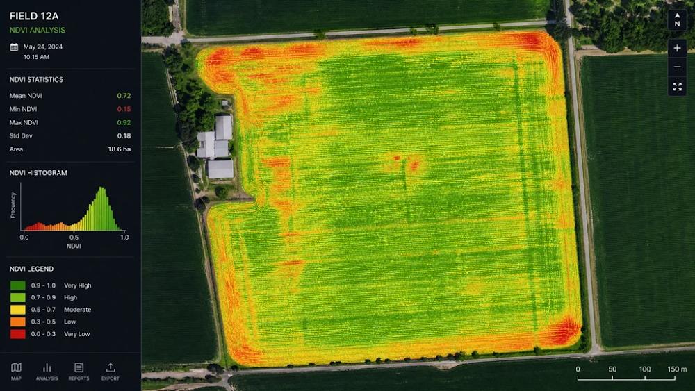
The drone revolution in North Queensland’s sugar cane industry represents only the first wave of technological transformation. The next frontier—already emerging across progressive farms—lies in artificial intelligence and machine learning systems that transform raw aerial imagery into predictive intelligence. While drones provide the eyes to see crop conditions comprehensively, AI provides the brain to understand what those conditions mean and what they’ll become.
This isn’t science fiction or distant future speculation. AI-powered agricultural analytics are being deployed right now across North Queensland’s cane fields, making predictions and recommendations that would have seemed impossible just five years ago. The technology is improving rapidly, becoming more accurate, more accessible, and more essential with each growing season.
From Images to Intelligence: How AI Transforms Drone Data
A single multispectral drone flight over a 200-hectare cane property generates approximately 2,000-3,000 high-resolution images containing billions of data points. Each pixel in each spectral band represents a measurement—a reflection value that indicates something about plant health, soil conditions, or environmental stress. For a human analyst, extracting meaningful patterns from this data deluge would require days or weeks of painstaking examination. For AI systems, it takes minutes.
Machine learning algorithms excel at pattern recognition—identifying subtle relationships and anomalies that human observers miss. The process begins with image classification: the AI examines each section of imagery and categorises what it sees. Healthy cane appears one way across multiple spectral bands; stressed cane shows different signatures. Water-stressed plants exhibit specific thermal patterns; nitrogen-deficient plants display characteristic colour shifts in the red-edge spectrum.
But AI goes far beyond simple classification. Advanced algorithms detect anomalies—areas that deviate from expected patterns in ways that indicate emerging problems. A cluster of plants showing slightly elevated temperatures and marginally reduced near-infrared reflectance might look normal to human eyes, but AI recognises it as the early signature of root disease or pest infestation. The system flags these anomalies for immediate farmer attention, often 5-7 days before visible symptoms would appear.
The most powerful capability is predictive modelling: using current conditions, historical patterns, and environmental data to forecast what will happen next. These models don’t just describe the present—they predict the future with remarkable accuracy.
Predictive Pest Management: Prevention Over Reaction
Traditional pest management is inherently reactive: farmers notice damage, identify the pest, then apply treatment. By the time this sequence completes, significant crop damage has occurred and pest populations have expanded across large areas. AI-powered predictive pest management flips this paradigm, enabling prevention rather than reaction.
The system works by correlating subtle crop stress patterns with pest activity. When canegrubs begin feeding on roots, affected plants show measurable stress responses days before visible damage appears: slightly reduced growth rates, minor changes in leaf temperature, and altered spectral signatures in specific wavelengths. Individually, these changes are too subtle for human detection. But AI models trained on thousands of examples recognise the pattern instantly.
A North Queensland farmer using AI-enhanced monitoring might receive an alert: “Block 14, northeast quadrant: spectral analysis indicates 87% probability of early-stage canegrub infestation. Recommend targeted soil treatment within 48 hours.” Ground verification confirms the prediction, and targeted treatment applied to just 8 hectares prevents an infestation that would have spread across 60+ hectares within two weeks. The economic impact: $3,000 in treatment costs prevents $75,000 in crop losses.
The models improve continuously. Each confirmed prediction strengthens the algorithm’s accuracy; each false alarm refines its discrimination. After two growing seasons, prediction accuracy for major pests typically exceeds 85-90%—far superior to human scouting that might detect only 40-60% of developing problems.
Disease Prediction: Seeing the Invisible
Plant diseases present an even greater challenge than pests because many pathogens operate invisibly within plant tissues for days or weeks before external symptoms appear. By the time a farmer notices yellowing leaves or lesions, the disease has often spread to neighbouring plants and treatment becomes difficult or impossible.
AI disease prediction leverages the fact that infected plants exhibit physiological changes before visible symptoms emerge. Orange rust, a fungal disease affecting North Queensland cane, alters leaf cellular structure 4-6 days before orange pustules appear. These structural changes affect how leaves reflect near-infrared and red-edge wavelengths—shifts of just 3-5% that multispectral sensors detect but humans cannot perceive.
Machine learning models trained on multispectral imagery from infected and healthy plants learn to recognise these pre-symptomatic signatures. The AI doesn’t just identify current infections—it predicts which plants will show symptoms in the coming week based on their current spectral profiles. This advance warning allows farmers to apply fungicides preventatively to affected areas and establish quarantine zones to prevent spread.
The accuracy is remarkable. Recent trials in the Herbert region demonstrated that AI models predicted orange rust outbreaks with 82% accuracy 5-7 days before visible symptoms, compared to 15% detection rates through conventional scouting at the same timepoint. Early intervention reduced disease spread by 60-70% and cut fungicide usage by 40% through precise targeting.
Yield Optimization: Predicting the Harvest
AI-powered yield prediction represents perhaps the most economically valuable application. These models integrate multiple data streams—drone imagery, weather data, soil characteristics, historical yield patterns, and even satellite observations—to forecast harvest volumes and sugar content weeks or months in advance.
The algorithms analyse dozens of variables: canopy density and height (measured through photogrammetric analysis), vegetation indices indicating plant vigour, thermal signatures revealing water stress, growth rates calculated from time-series imagery, and weather patterns affecting sugar accumulation. Machine learning identifies complex relationships between these variables and final yields—relationships too intricate for human analysis.
A typical prediction might state: “Block 7: predicted yield 108 tonnes/hectare ±6%, estimated sugar content 14.2 CCS ±0.4, optimal harvest window October 15-28.” This precision transforms logistics planning, financial forecasting, and harvest scheduling. Mills can optimise crushing schedules, farmers can prioritise high-value blocks, and financial institutions can assess loan risks with greater confidence.
Accuracy improves dramatically with local data. Initial models using generic parameters might predict yields within ±15% of actual results. After two seasons of local calibration with actual harvest data, accuracy improves to ±8-10%. After five seasons, the best models achieve ±5-7% accuracy—approaching the precision of physical sampling but available months earlier and covering 100% of the property rather than 0.5% samples.
Automated Flight Planning: Intelligent Autonomy
Modern agricultural drones don’t just fly predetermined patterns—they plan their own missions based on priorities, conditions, and objectives. AI-powered flight planning systems analyse multiple factors to optimise survey efficiency and data quality.
The system considers weather forecasts (avoiding flights during predicted wind gusts or rain), field characteristics (adjusting altitude and overlap for terrain variations), crop growth stages (prioritizing blocks at critical development phases), and recent imagery (focusing on areas showing concerning trends). The result: autonomous flight plans that maximise information value while minimizing flight time and battery consumption.
For example, the system might determine: “Block 3 requires high-resolution imaging due to suspected pest activity detected in previous flight; Block 8 can use standard resolution; Block 12 can be skipped this week as recent imagery shows stable conditions; weather window optimal 7-10 AM tomorrow.” The farmer reviews and approves the plan, and the drone executes it autonomously.
This intelligent automation allows one operator to manage multiple drones across extensive properties, dramatically improving operational efficiency. What once required careful manual planning for each flight now happens automatically, freeing farmers to focus on interpreting results and making management decisions.
Machine Learning Training: The Data Foundation
AI systems are only as good as the data they’re trained on. Effective agricultural machine learning requires extensive historical datasets linking imagery to ground-truth outcomes: which spectral signatures actually corresponded to pest infestations? Which thermal patterns predicted yield losses? Which vegetation indices correlated with final sugar content?
Building these datasets requires patience and systematic data collection. Early adopters spend 2-3 seasons gathering imagery and meticulously recording outcomes—pest locations, disease incidence, actual yields, treatment responses. This investment creates the training foundation that makes AI predictions possible.
The good news: accuracy improves rapidly with data accumulation. A model trained on one season’s data might achieve 60-70% prediction accuracy. Add a second season, and accuracy jumps to 75-80%. By the third season, accuracy often exceeds 85-90% for well-defined problems like major pest detection or yield estimation.
Transfer learning accelerates this process. Models trained on data from similar environments can be adapted to new locations with relatively small local datasets. A model developed in the Burdekin can be fine-tuned for Herbert region conditions using just one season of local data, achieving accuracy that would otherwise require 3-4 seasons of training from scratch.
Smart Farming Ecosystems: Connected Intelligence
The true power of AI emerges when drone data integrates with other information sources, creating comprehensive “smart farming” ecosystems. IoT soil sensors measuring moisture, temperature, and nutrient levels provide ground-truth data that validates and enhances aerial observations. Satellite imagery offers broader context and fills gaps between drone flights. Weather stations contribute real-time environmental data.
These diverse data streams feed into unified analytics platforms that provide holistic crop management insights. The system might correlate soil moisture sensor readings with thermal drone imagery to optimise irrigation scheduling, or combine satellite vegetation indices with drone pest detection to track infestation spread across regional scales.
The integration extends to autonomous machinery coordination. Precision spray drones receive treatment maps generated by AI analysis of multispectral imagery. Variable-rate fertiliser applicators adjust application rates based on AI-generated nutrient requirement maps. Harvest equipment receives yield prediction data to optimise cutting schedules and logistics.
The result is a fully connected agricultural operation where data flows seamlessly between sensors, drones, analytics platforms, and machinery—all coordinated by AI systems that optimise decisions across the entire production cycle.
Current Limitations and Future Potential
Despite impressive capabilities, current AI agricultural systems have limitations. Prediction accuracy, while good, isn’t perfect—85-90% accuracy means 10-15% of predictions are incorrect. Models trained on specific conditions may perform poorly when weather patterns or pest pressures deviate significantly from historical norms. Complex interactions between multiple stressors (heat + water stress + pest pressure) remain challenging to model accurately.
But the trajectory is clear: accuracy improves continuously as datasets expand and algorithms advance. New sensor technologies on the horizon—hyperspectral cameras capturing 100+ spectral bands, LiDAR systems measuring canopy structure in three dimensions, advanced thermal sensors with higher resolution—will provide richer data for even more sophisticated AI analysis.
The ultimate vision: fully autonomous crop management systems that monitor conditions continuously, predict problems before they develop, and coordinate interventions automatically with minimal human oversight. While fully autonomous farming remains years away, the foundational technologies are being deployed today.
Democratizing AI: Access for Smaller Farms
The sophistication of AI systems might seem accessible only to large corporate farms with dedicated data science teams. In reality, cloud-based analytics platforms and software-as-a-service offerings are democratising access. Farmers upload drone imagery to cloud platforms where powerful AI models process the data and return actionable insights—no local computing infrastructure or technical expertise required.
Services like DataFarming, FarmBot, and Agremo offer subscription-based AI analytics starting at $500-1,500 annually for small to medium properties. Farmers receive the same sophisticated analysis that would cost hundreds of thousands to develop independently. Cooperative data sharing amplifies benefits: anonymized data from multiple farms trains better models that benefit all participants.
Data Ownership and Privacy
As AI systems become central to farm management, data ownership and privacy concerns emerge. Who owns the imagery and analytics generated from a farmer’s property? Can service providers use farm data to train models sold to competitors? What happens if a data breach exposes sensitive farm information?
Progressive platforms address these concerns through clear data ownership agreements: farmers retain ownership of their data and control how it’s used. Anonymization protects privacy when data contributes to model training. Encryption and security protocols prevent unauthorized access. But farmers must carefully review terms of service and understand data policies before adopting AI platforms.
The Network Effect: Collective Intelligence
AI’s greatest advantage may be scalability through collective learning. One farmer’s data improves models for all farmers using the platform. A pest outbreak detected and confirmed on one property trains the model to recognise similar patterns elsewhere. Treatment outcomes—successes and failures—refine recommendations for the entire network.
Regional models optimised for North Queensland’s specific conditions—soil types, climate patterns, pest pressures, cane varieties—deliver superior accuracy compared to generic models. As adoption spreads, the collective dataset grows, and prediction accuracy improves for everyone. This network effect creates powerful incentives for participation: the more farmers contribute data, the better the system performs for all.
The integration of AI and drone technology isn’t replacing farmer expertise—it’s amplifying it. Farmers remain the decision-makers, but they’re now supported by analytical capabilities that would have seemed like magic a decade ago. In North Queensland’s cane fields, the future of agriculture is taking root today, one algorithm at a time.
🌱 Community and Industry Collaboration
The transformation of North Queensland’s sugar cane industry through drone technology is not a story of isolated innovation—it’s a testament to the power of collective action. While individual farmers have achieved remarkable results on their properties, the true revolution has emerged through unprecedented collaboration between growers, researchers, government agencies, and industry organizations. This cooperative approach has accelerated adoption, amplified benefits, and created outcomes that no single farm could achieve alone.
The Collaborative Ecosystem: Key Players and Partnerships
At the heart of this transformation lies a network of institutions working in concert. James Cook University, with its Cairns and Townsville campuses positioned directly within the sugar belt, has established dedicated agricultural technology research programs focusing on precision agriculture applications. Their researchers work alongside farmers in actual field conditions, testing drone systems, validating AI models, and measuring environmental outcomes with scientific rigor.
The University of Queensland contributes expertise in agricultural economics and sustainability modelling, helping quantify the financial and environmental returns from precision agriculture adoption. Their research has provided the economic evidence that convinced sceptical farmers and secured government funding for support programs.
The Queensland Department of Agriculture and Fisheries (DAF) serves as the crucial bridge between research and practice. Their extension officers work directly with farming communities, translating academic findings into practical recommendations, troubleshooting implementation challenges, and gathering feedback that shapes future research priorities. DAF’s network of demonstration farms across the region allows farmers to see drone technology in action before committing to adoption.
Industry bodies—particularly Canegrowers, the peak representative organization for cane growers, and the Australian Sugar Milling Council—have championed drone technology as essential for the industry’s sustainable future. They’ve coordinated training programs, negotiated group purchasing arrangements that reduce equipment costs, and advocated for policy frameworks that enable agricultural drone operations while ensuring safety and environmental protection.
Equipment suppliers and service providers have evolved from simple vendors into collaborative partners. Companies like XAG Australia, DJI Enterprise, and local service providers conduct on-farm trials, customise systems for tropical conditions, and provide ongoing technical support that ensures farmers extract maximum value from their investments. Their willingness to work with researchers and share performance data has accelerated technology refinement.
Regional agricultural cooperatives, such as the Burdekin Productivity Services and Herbert Cane Productivity Services Limited, have become innovation hubs. These farmer-owned organizations pool resources for equipment purchases, coordinate shared service arrangements, and facilitate knowledge exchange through field days and discussion groups.
Collaborative Research: Building Knowledge Together
The most powerful collaborations involve farmers contributing data to research initiatives that benefit the entire industry. Yield prediction model development exemplifies this approach. Individual farms provide drone imagery, soil data, and actual harvest results—anonymized to protect competitive information—that feed into machine learning algorithms. After three years of multi-property data collection involving over 40 farms across the Burdekin and Herbert regions, prediction models now achieve accuracy levels impossible with single-farm datasets.
Pest and disease monitoring networks represent another breakthrough collaboration. Farmers using drone surveillance report pest detections to a centralized database managed by DAF and university researchers. When multiple properties detect similar patterns, the system generates early warnings distributed across the region. This collective vigilance has prevented several potentially devastating pest outbreaks. In 2022, the network detected the early stages of a yellow canopy syndrome outbreak in the Tully region, enabling coordinated response that limited damage to less than 5% of regional production—compared to 20-30% losses in previous uncoordinated outbreaks.
Environmental impact studies measuring reef protection outcomes require scale that individual farms cannot provide. Collaborative research involving 60+ properties across multiple catchments has documented water quality improvements attributable to precision agriculture. These studies, combining drone adoption data with water monitoring results, provide the scientific evidence that justifies government support and satisfies export market sustainability requirements. The research has demonstrated that catchments with 60%+ drone adoption rates show 25-35% reductions in nutrient runoff—proof that collective action delivers measurable environmental benefits.
Precision application optimization studies tackle practical questions: What spray droplet size works best for different chemicals? How does wind speed affect application accuracy? What flight altitude optimises coverage while minimizing drift? Farmers contribute field trial data, researchers analyse results, and findings are shared industry-wide. This collaborative problem-solving has reduced the learning curve for new adopters from 2-3 years to 6-12 months.
Balancing Collaboration and Competition
A critical challenge in agricultural collaboration is balancing knowledge sharing with competitive advantage. North Queensland’s sugar industry has developed sophisticated approaches to this tension. Farmers contribute anonymized data—imagery and outcomes stripped of identifying information—to collective research while retaining proprietary control over their specific field data and management decisions.
The principle is simple: public good outcomes like reef protection and pest management benefit from shared data, while individual farm performance remains confidential. A farmer might share that “a 200-hectare property in the Burdekin with heavy clay soils achieved 15% yield improvement through precision nitrogen management,” without revealing which specific property or the exact management protocols used.
This approach works because the benefits of collaboration—better AI models, early pest warnings, industry-wide sustainability improvements—create value that exceeds any competitive disadvantage from shared learning. As one Ingham farmer explained: “We’re not competing on who has the best drone technology—we’re competing on who uses it most effectively. Sharing data makes everyone’s tools better, and that lifts the whole industry.”
Training and Knowledge Transfer: Accelerating Adoption
Formal training programs have been essential for widespread adoption. The Queensland Agricultural Training Colleges, in partnership with equipment suppliers, offer accredited courses in agricultural drone operation covering flight safety, sensor technology, data interpretation, and regulatory compliance. Over 800 farmers and farm workers have completed these programs since 2019, creating a skilled workforce capable of maximizing technology benefits.
Field days and demonstration sites provide hands-on learning opportunities. Canegrowers coordinates 15-20 field days annually across the sugar belt, where farmers observe drone operations, examine imagery analysis, and discuss results with experienced users. These events demystify the technology and address concerns that prevent adoption—particularly among older farmers who may feel intimidated by complex systems.
Farmer networks and discussion groups, both in-person and online, facilitate peer-to-peer learning. The “North Queensland Precision Ag” Facebook group has over 1,200 members sharing experiences, troubleshooting problems, and celebrating successes. When a farmer encounters a technical challenge—perhaps difficulty calibrating sensors or interpreting unusual imagery patterns—the collective expertise of the network typically provides solutions within hours.
Mentoring relationships between early adopters and new users have proven particularly valuable. Experienced farmers volunteer time to guide neighbours through initial adoption, sharing hard-won lessons about equipment selection, operational workflows, and data interpretation. This personal support reduces the anxiety and uncertainty that often accompany technology adoption, particularly for farmers who’ve managed their properties the same way for decades.
Government Support: Enabling the Transition
Government incentives have catalysed adoption by reducing financial barriers and providing technical support. The Queensland Government’s Reef Water Quality Program has allocated over $15 million since 2018 for precision agriculture adoption in reef catchments, with grants covering 50-75% of equipment costs for eligible farmers. These grants have enabled hundreds of smaller farms to adopt drone technology that would otherwise be financially out of reach.
Subsidies for sustainability practices reward farmers who achieve measurable environmental improvements. Farms demonstrating 30%+ reductions in chemical usage through precision agriculture receive annual payments of $50-80 per hectare—recognition that their environmental stewardship provides public benefits beyond their farm gate.
Extension services provided by DAF offer ongoing technical support at no cost to farmers. Extension officers conduct on-farm consultations, help interpret drone data, troubleshoot operational challenges, and connect farmers with research resources. This support is particularly crucial during the first 12-18 months of adoption when farmers are developing proficiency with new systems.
Policy frameworks enabling agricultural drone operations have evolved through collaborative dialogue between industry, regulators, and safety authorities. The Civil Aviation Safety Authority (CASA) has established streamlined certification processes for agricultural drone operators, balancing safety requirements with operational practicality. Industry input ensured these regulations enable productive farming operations rather than creating bureaucratic obstacles.
The Acceleration Effect: Collaboration Drives Innovation
Collaborative approaches create acceleration effects impossible through isolated adoption. Shared learning curves mean that lessons learnt by early adopters—which equipment performs best in tropical humidity, which spray parameters optimise coverage, which imagery processing workflows are most efficient—become immediately available to later adopters. This knowledge transfer compresses the learning period and reduces costly trial-and-error.
Economies of scale emerge as adoption spreads. Service providers can justify investing in advanced equipment and specialized expertise when serving a critical mass of customers. Equipment suppliers offer better pricing and support when addressing a substantial market. Training programs become economically viable when demand reaches threshold levels. These scale benefits reduce costs for all participants.
Rapid problem-solving occurs when challenges emerge. When a new pest species appeared in the Innisfail region in 2021, the collaborative network mobilized immediately. Researchers identified the pest, farmers shared detection data, and coordinated management strategies were implemented within days—response speed impossible without established collaborative infrastructure.
Industry-wide adoption creates critical mass that attracts further investment and innovation. As North Queensland’s sugar industry has become recognised as a global leader in agricultural drone adoption, international technology companies now test new systems in the region, providing farmers with early access to cutting-edge capabilities. This virtuous cycle of innovation and adoption reinforces the region’s competitive advantages.
Success Stories: Collaboration in Action
The Herbert River region’s coordinated yield improvement initiative demonstrates collaboration’s power. Thirty-seven farms contributed three years of drone imagery and harvest data to develop optimised management protocols for the region’s specific soil and climate conditions. Participating farms achieved average yield improvements of 8-12% while reducing input costs by 25-30%—results that individual farms would have taken a decade to achieve through isolated experimentation.
The Burdekin pest management network has prevented an estimated $12 million in crop losses since its 2020 establishment by enabling early detection and coordinated response to pest outbreaks. The network’s success has attracted international attention, with delegations from Brazil, India, and Thailand visiting to study the model for replication in their sugar industries.
Reef protection certification programs, developed collaboratively by industry bodies, environmental organizations, and government agencies, now certify over 40% of North Queensland’s cane production as meeting strict sustainability standards. This certification, impossible for individual farms to achieve credibly, provides market access and premium pricing that benefits all participants.
Cultural Transformation: From Competition to Cooperation
Perhaps the most profound change is cultural. North Queensland’s farming community has traditionally valued self-reliance and independence—farmers took pride in solving their own problems and maintaining competitive advantages through superior management. Drone technology and precision agriculture have revealed a different truth: the challenges facing the industry—environmental sustainability, climate adaptation, global competitiveness—are too large for individual solutions.
The shift from competitive isolation to collaborative advancement represents a fundamental reimagining of agricultural community. Farmers now recognise that industry-wide sustainability benefits everyone by protecting market access, maintaining social license to operate, and ensuring long-term viability. Pride in environmental stewardship has become a shared value that unites rather than divides.
As one Tully farmer reflected: “Twenty years ago, I would never have shared my farming data with anyone—that was my competitive edge. Now I realise that the real edge comes from being part of an industry that’s leading the world in sustainable production. That requires all of us working together.”
The Competitive Imperative of Collaboration
Paradoxically, collaboration has become essential for competitiveness. Individual farms cannot develop the AI models, research infrastructure, or sustainability certifications that global markets increasingly demand. But communities working together can create these capabilities, lifting all participants.
Export markets don’t evaluate individual farms—they assess regional and national industries. When North Queensland’s sugar industry demonstrates coordinated commitment to sustainability through collaborative adoption of precision agriculture, it enhances Australia’s reputation and market position. This collective brand value benefits every farmer in the region.
The lesson is clear: in modern agriculture, collaboration isn’t altruism—it’s strategic necessity. The farms and regions that thrive will be those that harness collective intelligence, share knowledge effectively, and coordinate action toward common goals. North Queensland’s sugar industry is proving that cooperation and competition can coexist, creating an agricultural future that’s both economically successful and environmentally sustainable.
🌾 Case Study: Drone Use in the Burdekin Region
The Burdekin region, stretching across the fertile delta plains south of Townsville, represents the powerhouse of Australian sugar production. This 130-kilometer stretch of agricultural land, fed by the Burdekin River—Queensland’s largest river by discharge—produces approximately 4 million tonnes of sugar cane annually, representing nearly 30% of Australia’s total sugar output. The region’s 520 cane farms cultivate roughly 90,000 hectares, with individual properties ranging from compact 50-hectare operations to sprawling 800-hectare enterprises.
The Burdekin’s agricultural dominance stems from its unique advantages: deep alluvial soils deposited over millennia by river flooding, reliable irrigation from the Burdekin Falls Dam (completed in 1987), and a climate that delivers consistent warmth without the extreme rainfall that challenges coastal regions. Yet these advantages have historically come with significant challenges: the region’s flat topography creates drainage complications, its reliance on irrigation demands precise water management, and its distance from the coast (40-80 kilometres inland) means pest pressures can build undetected across vast, uniform landscapes.
It’s within this context that drone technology has achieved some of its most dramatic transformations. The following case studies, drawn from real farms across the Burdekin delta, illustrate how precision agriculture is reshaping one of Australia’s most important agricultural regions.
Case Study 1: Transforming a Mid-Scale Family Operation Near Ayr
The family’s 280-hectare property, located southwest of Ayr in the heart of the lower Burdekin, represents a typical mid-scale operation that has farmed sugar cane for three generations. In 2019, before drone adoption, the farm produced approximately 26,500 tonnes annually (averaging 95 tonnes per hectare), with sugar content averaging 13.8 CCS (commercial cane sugar units). Annual operating costs ran approximately $420,000, with fertiliser ($78,000), pesticides ($34,000), and labour for monitoring and spraying ($42,000) representing the largest variable expenses.
They faced persistent challenges that eroded profitability. Their property spans three distinct soil types—heavy clay in the western blocks, sandy loam in the eastern sections, and transitional soils between—yet conventional management treated all areas identically. Canegrub infestations appeared sporadically, often discovered only after significant damage occurred. Irrigation uniformity across the property was questionable, with some blocks showing signs of water stress while others remained waterlogged. Most frustratingly, they suspected significant yield variation across different zones but lacked data to understand why or how to address it.
The decision to adopt drone technology came in late 2019, motivated by three factors: mounting pressure to meet sustainability certification requirements for export markets, a severe canegrub outbreak that cost an estimated $35,000 in lost production, and encouragement from their agronomist who had seen impressive results on neighbouring properties. Initial concerns centred on cost—the $68,000 investment in a multispectral imaging drone and spray drone represented their largest equipment purchase in five years—and technical complexity. “I’m 58 years old,” the farmer admitted. “I can operate a tractor blindfolded, but computers and I have never been friends.”
Implementation began with a three-day training course through Burdekin Productivity Services in January 2020, followed by mentoring from an early-adopter neighbour. The Mitchells started conservatively, using the imaging drone for crop monitoring while contracting spray services until they gained confidence. Their initial focus was on three applications: mapping crop vigour variations to guide variable-rate fertiliser application, early pest detection through weekly multispectral surveys, and thermal imaging to identify irrigation system problems.
The results over three growing seasons (2020-2023) exceeded expectations across every metric:
Chemical Use Reduction: Nitrogen fertiliser application dropped from 168 kg/ha to 118 kg/ha on average—a 30% reduction—while actually improving crop nutrition uniformity. Precision targeting meant high-performing zones received less fertiliser while deficient areas received more, optimizing the total. Annual fertiliser costs fell from $78,000 to $52,000, saving $26,000 annually. Pesticide use declined even more dramatically: targeted spraying reduced insecticide applications by 55%, from $34,000 to $15,000 annually, while achieving superior pest control through early intervention.
Yield Improvements: Average yields increased from 95 to 104 tonnes per hectare by 2022—a 9.5% improvement—while sugar content rose from 13.8 to 14.3 CCS. The 280-hectare property now produces 29,120 tonnes annually, an increase of 2,620 tonnes. At $480 per tonne (including quality premiums), this represents additional gross revenue of $1.26 million annually. After accounting for harvest and transport costs ($95 per tonne), net additional revenue is approximately $1.01 million.
Cost Savings: Beyond chemical reductions, labour costs for crop monitoring fell from $42,000 to $16,000 annually as drone surveys replaced manual scouting. Fuel costs for ground-based spraying equipment dropped by $8,000 annually. Total annual operating cost savings: $72,000.
Water Efficiency: Thermal imaging identified three irrigation system failures in 2020 alone—broken underground pipes and malfunctioning sprinklers—that would have gone undetected for weeks using conventional monitoring. Early detection prevented an estimated $85,000 in yield losses. Precision irrigation scheduling based on thermal stress mapping reduced water usage by 18% while improving crop performance, saving approximately $12,000 annually in pumping costs.
Environmental Benefits: Water quality monitoring in the adjacent Barratta Creek, conducted by James Cook University researchers, showed a 32% reduction in nitrogen concentrations during the 2021-2022 wet season compared to pre-adoption baselines. The farm achieved Bonsucro sustainability certification in 2021, enabling access to premium markets.
ROI Calculation: Against the initial $68,000 investment plus ongoing costs of $8,500 annually (batteries, maintenance, software), the farm achieved total annual benefits of $1.09 million (yield improvements plus cost savings). The payback period was 7.2 weeks. By the end of year three, cumulative net benefits exceeded $3.1 million.
Specific Problem-Solving Examples: In March 2021, weekly multispectral monitoring detected early-stage yellow canopy syndrome affecting just 8 hectares in the northeast corner. Targeted treatment within 48 hours contained the outbreak, preventing spread across an estimated 45-60 hectares—saving $55,000-70,000 in potential losses. In October 2022, thermal imaging revealed that Block 7’s irrigation system was delivering 40% less water than intended due to a partially blocked main line. Repairs completed within 24 hours prevented yield losses estimated at $28,000 across the 22-hectare block.
They also used drone imagery to optimise field boundaries and access roads, identifying 3.2 hectares of unproductive edge areas that were converted to improved drainage channels, reducing waterlogging in adjacent productive zones and improving yields by 12-15% across 18 hectares.
Communication Transformation: Real-time imagery accessible via tablet devices transformed coordination between the owner (who manages overall operations), his son (who handles day-to-day field work), and their three seasonal workers. “Before drones, I’d tell my son to check the western blocks for pest problems,” he explained. “He’d spend half a day walking around, come back and say ‘looks okay.’ Now we both look at the same imagery, identify exactly which areas need attention, and we goes straight there with GPS coordinates. What took half a day now takes 45 minutes, and we’re looking at 100% of the crop instead of 2%.”
Challenges and Solutions: The learning curve proved steeper than anticipated. Initial imagery interpretation was confusing—distinguishing between nitrogen deficiency, water stress, and pest damage required three months of practice and multiple consultations with their agronomist. A propeller strike during a low-altitude spray operation in April 2020 caused $3,200 in damage and grounded the spray drone for two weeks, teaching hard lessons about obstacle awareness. Software glitches occasionally corrupted imagery data, requiring re-flights. But systematic training, manufacturer support, and peer network assistance resolved each challenge.
Personal Impact: The technology has transformed our relationship with farming. “For 35 years, I managed by intuition and experience—walking fields, looking at plants, making educated guesses,” he reflected. “Now I manage by data. I know exactly what’s happening across every hectare. The stress of wondering if problems are developing unseen is gone. And honestly, farming is intellectually interesting again in ways it hasn’t been since I was young.” The transformation has convinced my son, to commit to taking over the operation—a decision uncertain before drone adoption made the farm’s future viability clear.
Future Plans: They are now integrating soil moisture sensors across the property to complement drone thermal imaging, creating a comprehensive water management system. They’re participating in a James Cook University trial of hyperspectral imaging for early disease detection. And they’re exploring autonomous harvester coordination using drone-generated yield maps to optimise cutting sequences.
Case Study 2: Large-Scale Corporate Operation Near Giru
A 680-hectare corporate-owned property near Giru, managed by an experienced agronomist , represents the other end of the adoption spectrum. This operation, producing approximately 72,000 tonnes annually pre-adoption, implemented a comprehensive precision agriculture system in 2018—among the earliest adopters in the region.
Starting from a position of already-efficient conventional management, the operation still achieved remarkable improvements: 22% reduction in nitrogen use (from 175 kg/ha to 136 kg/ha), 48% reduction in pesticide applications, and 6.8% yield improvement (from 106 to 113 tonnes per hectare). The larger scale amplified benefits: annual cost savings of $186,000 combined with additional production worth $2.1 million (net $1.68 million after harvest costs).
The operation’s most significant achievement was infrastructure optimization. Drone mapping revealed that their irrigation channel network, designed in 1992, had developed significant inefficiencies. Siltation in key channels reduced flow rates by 30-40% in some areas, while other sections delivered excess water. A $240,000 infrastructure upgrade guided by drone data improved irrigation uniformity across the property, reducing water usage by 24% while increasing yields in previously under-irrigated zones by 18-22%.
The operation achieved Bonsucro certification in 2019 and Rainforest Alliance certification in 2021, enabling premium pricing of $35-45 per tonne above standard rates—worth approximately $2.5 million annually. This premium pricing, combined with operational efficiencies, improved the property’s financial stability sufficiently to secure favourable financing for a $4.2 million harvester upgrade in 2022.
Case Study 3: Small Operation Achieving Sustainability
A 95-hectare property near Home Hill, operated by a third-generation farmer, demonstrates that drone benefits scale to smaller operations. Unable to justify equipment purchase, they contract drone services from a local drone contractor, spending approximately $14,000 annually for bi-weekly imaging and targeted spray applications.
Despite the service model, they achieved 28% reduction in chemical costs (from $31,000 to $22,000 annually), 7.2% yield improvement (from 92 to 98.6 tonnes per hectare), and total annual benefits of approximately $168,000 against service costs of $14,000—an ROI of 1,100%. The operation achieved Bonsucro certification in 2022, and reports that drone adoption “saved the farm” by enabling sustainability certification that preserved access to export markets worth 70% of his revenue.
Regional Environmental Impact
Collectively, the Burdekin region’s widespread drone adoption—now exceeding 65% of properties—has produced measurable environmental improvements. Water quality monitoring at five sites across the Burdekin River catchment shows average nitrogen concentration reductions of 23-28% during wet season discharge events (2020-2023 compared to 2015-2018 baselines). Pesticide detection frequencies have declined by 35-42% for commonly used herbicides. These improvements directly benefit the Great Barrier Reef, located 40-80 kilometres downstream.
The Burdekin’s transformation demonstrates that drone technology delivers transformative results across operations of all scales, turning environmental stewardship from cost burden into competitive advantage while preserving the agricultural heritage that defines the region.
🌊 Protecting the Reef, Sustaining the Industry
The relationship between North Queensland’s sugar cane farmers and the Great Barrier Reef has undergone a profound transformation—from perceived antagonism to essential partnership. This shift represents more than a technological success story; it’s a fundamental reimagining of how agriculture and environmental conservation can not only coexist but actively reinforce each other. At the heart of this transformation lies a simple truth: the farmers who work the land adjacent to the world’s most iconic reef ecosystem have become its most effective defenders.
Agriculture: The Primary Controllable Factor
While climate change poses the greatest long-term threat to the Great Barrier Reef through ocean warming and acidification, agricultural runoff represents the primary threat that can be addressed through immediate, practical action. Unlike global carbon emissions, which require international coordination and decades-long transitions, nutrient and pesticide pollution from cane fields can be reduced dramatically within a single growing season through precision management.
This distinction is crucial. Marine scientists estimate that even if global warming were halted tomorrow, the reef would require decades to recover from existing thermal stress. But water quality improvements deliver measurable benefits within months. Reduced nutrient loads mean fewer algal blooms during the next wet season. Lower pesticide concentrations immediately reduce stress on coral zooxanthellae. Improved water clarity enhances photosynthesis and coral resilience within weeks.
Sugar cane farming, as the dominant agricultural land use across reef catchments, occupies a unique position of responsibility and opportunity. The industry’s decisions—about fertiliser application rates, pesticide use, and management practices—directly determine whether 40,000 tonnes of nitrogen or 25,000 tonnes reach reef waters annually. That difference, between business-as-usual and precision agriculture, translates to the difference between continued reef degradation and the beginning of recovery.
The Urgency Before Drones: An Impossible Dilemma
For decades, the sugar industry faced what seemed like an impossible choice: meet increasingly stringent environmental targets or maintain economic viability—but not both. The Reef 2050 Water Quality Improvement Plan’s targets—60% reduction in nitrogen loads, 60% reduction in pesticide loads—appeared achievable only through dramatic production cuts that would devastate farming communities.
Traditional farming methods offered no pathway to these reductions while maintaining yields. Blanket fertiliser application was already optimised based on average crop requirements; further reductions meant under-fertilizing crops and accepting lower production. Pesticide use was already conservative by global standards; additional cuts risked uncontrolled pest outbreaks. The mathematics seemed brutal: environmental compliance would cost the industry hundreds of millions in lost production, threatening the viability of hundreds of farms and thousands of jobs.
Government mandates created mounting pressure. Export markets, particularly in Europe and North America, implemented strict sustainability requirements. Major buyers—Coca-Cola, Nestlé, Unilever—demanded certified sustainable sugar or threatened to source elsewhere. The Australian sugar industry faced an existential crisis: demonstrate measurable environmental improvement or lose access to premium markets worth 40-50% of export revenue.
The timeline was unforgiving. Reef health was deteriorating rapidly, with back-to-back bleaching events in 2016-2017 killing half the corals in some northern sections. Scientists warned that without immediate water quality improvements, the reef’s capacity for recovery would be permanently compromised within a decade. The industry had perhaps five years to prove it could be part of the solution—or face regulatory restrictions that might end sugar production in reef catchments entirely.
Drones: Enabling the Impossible
Precision agriculture powered by drone technology shattered the false choice between environment and economy. For the first time, farmers could reduce chemical inputs by 30-40% while improving crop performance. The key was eliminating waste—applying chemicals only where needed, in quantities matched to actual requirements, at optimal times.
The environmental mathematics transformed completely. A farm reducing nitrogen application from 180 kg/ha to 120 kg/ha through precision management achieves a 33% reduction—more than halfway to the 60% regional target—while actually improving yields through better-targeted nutrition. Multiply this across thousands of farms, and the Reef 2050 targets shift from impossible to achievable.
Drone adoption directly addresses every major pathway of agricultural impact on the reef:
Reduced nutrient runoff means fewer algal blooms that smother corals and reduce water clarity. Precision nitrogen management cuts dissolved inorganic nitrogen loads by 30-40%, directly reducing the fuel for harmful algal growth. The result: clearer water, more light reaching corals, and reduced competition from algae for reef space.
Reduced pesticide loads lower chronic stress on coral zooxanthellae—the symbiotic algae that provide corals with energy. Herbicides like diuron, which inhibit photosynthesis in both weeds and zooxanthellae, decline by 40-60% in waterways draining precision-managed catchments. Corals maintain healthier zooxanthellae populations, improving their resilience to thermal stress and disease.
Improved water quality creates ecosystem-wide benefits. Better light penetration supports seagrass beds that stabilise sediments and provide habitat for juvenile fish. Reduced nutrient loads support balanced microbial communities rather than pathogenic blooms. The entire coastal ecosystem becomes more resilient, better able to withstand the climate stresses that cannot be immediately controlled.
The Virtuous Cycle: Environment Enabling Economy
Drone adoption has created a self-reinforcing cycle where environmental improvement drives economic success, which enables further environmental investment. The cycle operates at multiple levels:
Precision agriculture reduces input costs by $150-250 per hectare while improving yields by 5-10%, generating $200-400 per hectare in additional profit. This improved profitability enables farms to invest in advanced technologies—AI analytics, soil sensors, infrastructure upgrades—that deliver further environmental and economic gains.
Environmental improvements enable sustainability certification—Bonsucro, Rainforest Alliance, and other standards that premium markets require. Certification provides price premiums of $20-45 per tonne, worth $200,000-450,000 annually for a typical 200-hectare farm. These premiums more than cover the costs of precision agriculture systems, making environmental stewardship directly profitable.
Market access secured through sustainability credentials protects the industry’s long-term viability. As global buyers tighten requirements, Australian sugar meeting strict environmental standards maintains access to markets where uncertified competitors face exclusion. This market security justifies continued investment in innovation, perpetuating the cycle.
The industry’s environmental reputation, once a liability, has become a competitive advantage. Australian sugar is increasingly recognised as among the world’s most sustainably produced, commanding premium prices and preferred supplier status. This reputational capital attracts investment, supports rural communities, and ensures the industry’s future.
Policy Alignment: When Incentives Converge
Remarkably, government policy, market forces, and farmer interests have aligned around precision agriculture in ways rarely seen in environmental policy. The Queensland Government’s Reef Water Quality Program provides grants covering 50-75% of drone system costs, reducing financial barriers to adoption. These incentives recognise that farmer environmental stewardship provides public benefits—reef protection—worth far more than the subsidy costs.
The Reef 2050 targets, once seen as threatening industry viability, now provide clear goals that precision agriculture can achieve. Catchment modelling shows that 70-80% adoption of precision practices would meet or exceed the 60% reduction targets while maintaining or improving production. The pathway to compliance is clear, achievable, and economically beneficial.
International sustainability standards—Bonsucro, ISO 14001, Rainforest Alliance—align with precision agriculture practices. Farms adopting drone technology automatically satisfy most certification requirements, streamlining the path to premium markets. What could have been competing demands—government targets, market standards, profitability requirements—have converged into a unified framework supporting the same practices.
Quantifiable Environmental Outcomes: Measuring Success
The environmental benefits of widespread drone adoption are not theoretical—they’re measurable and substantial. Water quality monitoring across reef catchments documents the transformation:
The Burdekin catchment, with 65%+ drone adoption, shows 23-28% reductions in wet season nitrogen loads compared to pre-adoption baselines. If adoption reaches 80% by 2026, modelling predicts 35-45% total reductions—approaching the 60% target.
The Herbert catchment, where adoption exceeds 55%, has recorded 18-25% reductions in dissolved inorganic nitrogen and 30-38% reductions in pesticide detection frequencies. Projections suggest that 75% adoption would achieve 40-50% total load reductions.
Across all major reef catchments, the trend is consistent: each 10% increase in precision agriculture adoption correlates with 4-6% reductions in nutrient loads and 6-9% reductions in pesticide loads. The relationship is nearly linear, meaning the path to meeting targets is straightforward: accelerate adoption.
Marine scientists project that if current adoption trends continue, reaching 75-80% coverage by 2027, reef water quality will improve sufficiently to reduce algal bloom frequency by 40-50%, improve water clarity by 20-30%, and enhance coral resilience to thermal stress by 15-25%. These improvements won’t prevent climate-driven bleaching, but they’ll significantly improve coral survival rates and recovery capacity.
From Environmental Concern to Global Leader
The transformation of Australian sugar’s reputation represents one of the most remarkable turnarounds in agricultural environmental relations. A decade ago, the industry faced criticism from environmental groups, scepticism from international buyers, and regulatory pressure from government. Today, it’s increasingly recognised as a global leader in sustainable tropical agriculture.
This reputational shift delivers tangible benefits. Australian sugar commands premium prices in quality-conscious markets. International delegations visit North Queensland to study precision agriculture implementation. Equipment manufacturers test new technologies in the region, providing farmers with early access to innovations. The industry’s leadership in sustainability has become a source of pride and competitive advantage.
The broader implications extend beyond sugar. North Queensland’s success demonstrates that agriculture and environmental protection are not inherently opposed—they can be mutually reinforcing when enabled by appropriate technology and policy frameworks. This model is being studied by other agricultural sectors and regions worldwide, from Brazilian coffee to Southeast Asian palm oil, as proof that intensive agriculture can coexist with sensitive ecosystems.
A Turning Point: Stakeholders Aligned
Perhaps the most profound change is the alignment of stakeholders once seen as adversaries. Farmers and environmental organisations now collaborate on water quality monitoring and best practice development. Government agencies support rather than regulate, providing incentives and technical assistance. Research institutions partner with industry to refine technologies and measure outcomes. Market forces reward rather than punish environmental stewardship.
This alignment wasn’t inevitable—it required technology that made environmental improvement economically beneficial, policy frameworks that supported rather than mandated change, and willingness from all parties to move beyond entrenched positions. Drone technology provided the enabling tool, but the transformation required collective commitment to finding solutions rather than assigning blame.
The result is a new paradigm where reef protection and industry sustainability are recognised as inseparable. Farmers understand that their long-term viability depends on maintaining the reef’s health and the industry’s environmental reputation. Conservationists recognise that working farmers are essential allies in reef protection, not obstacles to overcome. Government and markets provide frameworks that reward environmental stewardship rather than treating it as a cost to be minimised.
The Window of Opportunity
The urgency remains acute. The Great Barrier Reef continues to face existential threats from climate change, with warming waters and ocean acidification creating conditions that may eventually overwhelm even the healthiest ecosystems. But the window for effective action on water quality—the threat that can be controlled—is open now, and drone technology provides the tools to act decisively.
Every growing season that passes with expanded precision agriculture adoption is a season of reduced pollution, improved water quality, and enhanced reef resilience. Every farm that transitions from conventional to precision management is a farm that becomes part of the solution. The cumulative impact of thousands of individual decisions—to adopt drones, embrace data-driven management, and prioritise sustainability—is creating measurable environmental improvement at the scale the reef requires.
This is the promise and the imperative: technology has provided solutions to problems once thought intractable. The sugar industry has demonstrated that environmental stewardship and economic success can align. The reef has gained powerful defenders in the farmers who work the land that feeds it. What remains is to accelerate adoption, deepen commitment, and prove that agriculture and environment can not only coexist but thrive together—protecting both the reef and the communities that depend on it for generations to come.
🔮 The Future of Drone-Assisted Cane Farming
The drone revolution currently transforming North Queensland’s sugar cane industry represents only the opening chapter of a far more profound agricultural transformation. Looking ahead to the next 5-10 years, the trajectory is clear: drones will evolve from standalone tools into nodes within fully integrated, AI-orchestrated farming ecosystems that blur the boundaries between digital and physical agriculture. The future isn’t just about better drones—it’s about reimagining farming itself as a data-driven, autonomous, and hyper-responsive system that operates with precision unimaginable just a decade ago.
The Connected Farm: A Unified Intelligence Network
The agricultural operation of 2030 will function as a seamless network where multiple data streams converge into unified intelligence. Satellite imagery, refreshed daily or even hourly through constellations like Planet Labs and emerging hyperspectral satellites, will provide continuous broad-scale monitoring that identifies regional patterns and anomalies. When satellite data detects concerning trends across a 50-hectare zone, it automatically triggers targeted drone surveys for detailed investigation. The drone imagery, in turn, activates ground-based IoT sensors—soil moisture probes, nutrient analysers, and microclimate stations—that provide granular validation of aerial observations.
This multi-layered sensing creates unprecedented situational awareness. A farmer won’t just know that Block 7 shows signs of water stress; they’ll know precisely which 2-hectare subsection is affected, the exact soil moisture deficit at three depth levels, the predicted time until crop damage occurs, and the optimal irrigation response—all delivered as a single actionable recommendation generated by AI systems processing data from satellites, drones, and ground sensors simultaneously.
Autonomous machinery coordination will transform operations from sequential tasks into choreographed symphonies. Spray drones will receive treatment maps generated in real-time from morning drone surveys, execute precision applications by afternoon, and transmit completion data that updates crop health models by evening. Variable-rate fertiliser applicators will adjust application rates meter-by-meter based on AI analysis of yesterday’s multispectral imagery. Autonomous harvesters, guided by yield prediction models refined throughout the growing season, will optimise cutting sequences to maximise sugar content and minimise field time—all coordinated through central AI systems that manage logistics, equipment scheduling, and resource allocation across entire properties or even regional cooperatives.
Technological Horizons: The Next Generation of Sensing
The sensor technologies emerging from research laboratories promise to make today’s multispectral imaging seem primitive by comparison. Hyperspectral cameras capturing 100-200+ spectral bands—compared to the 5-10 bands of current systems—will detect biochemical signatures invisible to conventional sensors. These systems will identify specific nutrient deficiencies (distinguishing nitrogen from potassium from micronutrient deficits), detect disease pathogens days earlier through subtle cellular changes, and even assess sugar content in standing cane weeks before harvest through spectral analysis of plant biochemistry.
LiDAR (Light Detection and Ranging) systems, already revolutionising autonomous vehicles, will bring three-dimensional precision to crop monitoring. Rather than viewing cane fields as flat images, LiDAR creates detailed 3D models showing canopy structure, plant height variations, and biomass distribution with centimetre-level accuracy. This data enables precise yield estimation, identifies lodging risks before storms, and guides harvest equipment through optimal cutting patterns that maximise recovery and minimise losses.
Advanced thermal sensors with resolution approaching that of visible-light cameras will detect temperature variations of 0.1°C or less, identifying water stress, disease hotspots, and even pest activity through the subtle heat signatures of insect metabolism. Combined with AI analysis, these sensors will predict irrigation needs 48-72 hours in advance and detect pest infestations when populations are still in single digits per square meter—enabling intervention before any economic damage occurs.
The integration of autonomous harvesters with real-time drone data represents perhaps the most transformative near-term advance. Harvesters equipped with on-board sensors and AI systems will adjust cutting height, speed, and processing parameters continuously based on crop conditions mapped by drones hours earlier. The result: optimised sugar recovery, reduced trash content, and harvest efficiency improvements of 15-25% compared to conventional operations.
Soil robotics—small autonomous vehicles that navigate fields collecting soil samples, measuring compaction, and even conducting localised treatments—will provide ground-truth data that validates and enhances aerial observations. These systems, currently in advanced trials, will create soil health maps with resolution and frequency impossible through manual sampling, enabling truly precision soil management.
Looking further ahead, quantum computing applications may eventually enable agricultural modelling of unprecedented complexity—simulating entire farm ecosystems at molecular levels, predicting outcomes of management decisions with near-perfect accuracy, and optimizing across hundreds of variables simultaneously. While still speculative, quantum agriculture could arrive within 15-20 years, representing another paradigm shift in farming intelligence.
Operational Evolution: Toward Full Autonomy
The trajectory toward fully autonomous farming operations is accelerating. Within five years, spray drones will operate with minimal human oversight—launching automatically when weather conditions are optimal, executing treatment plans generated by AI analysis, and returning to charging stations without human intervention. Farmers will shift from operators to supervisors, monitoring multiple autonomous systems simultaneously and intervening only when systems flag decisions requiring human judgment.
Predictive maintenance systems, already common in aviation and manufacturing, will transform farm equipment reliability. Sensors monitoring machinery performance will detect developing problems days or weeks before failures occur, automatically scheduling maintenance during optimal windows and ordering replacement parts before breakdowns happen. The costly downtime that currently plagues harvest operations—a broken harvester during peak season can cost $50,000-100,000 in delayed cutting—will become increasingly rare.
Robotic weeding systems, combining computer vision with precision mechanical or laser-based weed elimination, will reduce herbicide dependence even further. These systems, already deployed in vegetable and row crop production, will adapt to sugar cane within 3-5 years, targeting individual weeds with millimetre precision while leaving crop plants untouched. The result: near-zero herbicide use in many applications, further reducing environmental impact and operating costs.
Real-time pest detection integrated with biological control systems represents another frontier. Drones equipped with advanced sensors will detect pest activity and automatically deploy targeted biological controls—releasing beneficial insects, applying pheromone disruptors, or triggering localized treatments—within hours of detection. This rapid-response capability will enable pest management with minimal chemical use, relying instead on ecological approaches that work with natural systems rather than against them.
Weather prediction integration will evolve from simple forecast consultation to dynamic operational optimization. AI systems will continuously analyse weather models, adjusting irrigation schedules, spray timing, and harvest plans in real-time as forecasts update. When a weather system’s track shifts, potentially bringing unexpected rain to previously dry forecasts, the system automatically reschedules operations to avoid losses—all without human intervention.
Business Model Transformation: From Ownership to Services
The economics of agricultural technology are shifting fundamentally. The future lies not in equipment ownership but in service subscriptions and outcome-based models. Rather than purchasing $90,000 drone systems, farmers will increasingly subscribe to comprehensive precision agriculture services—paying monthly fees for unlimited drone flights, AI analytics, and agronomic recommendations. This “agriculture-as-a-service” model reduces capital requirements, ensures access to latest technologies, and shifts risk from farmers to service providers.
Software and data analytics are becoming the primary value drivers, with hardware increasingly commoditized. The competitive advantage lies not in owning superior drones—equipment capabilities are converging—but in having better algorithms, more comprehensive datasets, and more sophisticated AI models. Companies like John Deere, Bayer, and emerging AgTech start-ups are positioning themselves as agricultural data platforms rather than equipment manufacturers, recognising that long-term value lies in information, not machinery.
Agricultural data marketplaces are emerging where farmers can monetise their anonymized farm data, selling insights to researchers, input suppliers, and other farmers. A grower who has perfected nitrogen management for specific soil types might license their management protocols through data platforms, creating new revenue streams while accelerating industry-wide improvement. These marketplaces will create network effects where data value increases exponentially as participation grows.
The Human Element: Farmers as Data Scientists
The transformation of farming from physical labour to knowledge work is accelerating. Tomorrow’s successful cane farmers will spend less time operating machinery and more time analysing data, interpreting AI recommendations, and making strategic decisions about crop management, market timing, and long-term investments. The skill set is shifting from mechanical aptitude and physical endurance to data literacy, systems thinking, and technological fluency.
This evolution demands new approaches to agricultural education and training. Universities are already developing agricultural data science programs; within a decade, these will be standard pathways into farming careers. The industry must attract technically skilled young people who might otherwise pursue careers in technology or finance, offering the appeal of meaningful work that combines cutting-edge technology with environmental stewardship and food production.
Career pathways are diversifying. Agricultural drone operators, data analysts, AI system managers, and precision agriculture consultants represent emerging professions that didn’t exist a decade ago. These roles offer attractive compensation, intellectual challenge, and work-life balance that traditional farming often lacked—helping address the industry’s long-standing challenge of attracting and retaining young talent.
Global Replication and Competitive Dynamics
North Queensland’s success is attracting global attention. Sugar industries in Brazil, India, Thailand, and other major producing regions are studying the Australian model for replication. Within 5-10 years, precision agriculture will likely become standard practice globally, with international sustainability standards converging around practices pioneered in North Queensland. This global adoption will level the competitive playing field—early adopters’ advantages will diminish as technology becomes commodity rather than differentiator.
Maintaining competitive edge will require continuous innovation. Farms and regions that pioneered drone adoption must now lead in AI integration, autonomous systems, and next-generation technologies. The risk of complacency is real: technology that provides advantage today becomes baseline expectation tomorrow. Sustained success demands ongoing investment in innovation, willingness to experiment with emerging technologies, and organizational cultures that embrace change.
The Sustainability Frontier: Beyond Water Quality
Having largely solved the water quality challenge, the industry’s sustainability focus is expanding. Carbon neutrality is emerging as the next frontier—measuring and reducing greenhouse gas emissions from farming operations, sequestering carbon in soils through regenerative practices, and potentially achieving net-negative emissions through optimised management. Drone-enabled precision agriculture contributes by reducing fuel consumption (fewer tractor passes), minimising fertiliser use (reducing nitrous oxide emissions), and enabling practices like cover cropping and reduced tillage that build soil carbon.
Climate adaptation and resilience are becoming central concerns as weather patterns shift and extreme events intensify. The monitoring and rapid-response capabilities enabled by drones will prove essential for managing increasing climate volatility. Farms that can detect and respond to heat stress, flooding, or pest outbreaks within hours rather than days will survive and thrive; those relying on conventional management will struggle.
Challenges on the Horizon
The path forward isn’t without obstacles. Data security and privacy concerns will intensify as farming becomes increasingly digital. Cyberattacks on agricultural systems—ransomware targeting farm management software, data breaches exposing proprietary information—represent emerging threats requiring robust security measures and industry-wide protocols.
Technology obsolescence risks are real. Equipment purchased today may be outdated within 5-7 years, requiring continuous reinvestment that strains farm finances. The pace of change may exceed some farmers’ capacity to adapt, potentially creating a divide between technologically advanced operations and those unable to keep pace.
Maintaining profitability amid intensifying competition and potentially declining technology premiums will challenge the industry. As precision agriculture becomes universal, the cost savings and yield improvements it provides will be competed away through lower sugar prices, requiring continuous efficiency gains just to maintain current profitability.
Climate change itself remains the ultimate wild card. If warming accelerates beyond current projections, even the most sophisticated agricultural technology may prove insufficient to maintain productivity in regions that become too hot or experience catastrophic weather events with increasing frequency.
Regulatory Evolution and Market Demands
Environmental regulations will almost certainly tighten further. The Reef 2050 targets represent a starting point, not an endpoint. Future requirements may demand 80-90% reductions in nutrient loads, near-zero pesticide use, and comprehensive carbon accounting. Precision agriculture provides the tools to meet these requirements, but continuous improvement will be necessary.
Traceability and certification requirements are expanding. Consumers and buyers increasingly demand proof of sustainable production—not just certifications but detailed data showing exactly how crops were grown, what inputs were used, and what environmental outcomes resulted. Blockchain-based traceability systems integrated with drone data will likely become standard, providing transparent supply chains from field to consumer.
The regulatory framework for autonomous agricultural operations will need development. As drones and robots operate with increasing independence, questions of liability, safety standards, and operational protocols will require clear regulatory answers. Industry must engage proactively in shaping these regulations to ensure they enable innovation while protecting safety and environmental values.
A Vision of Possibility
The future of North Queensland’s sugar cane industry—and agriculture globally—is one of extraordinary possibility. Farms operating as intelligent, responsive ecosystems that optimise productivity while regenerating environmental health. Farmers empowered by technology to make decisions of unprecedented precision and impact. Rural communities thriving through high-value agricultural careers that combine technological sophistication with environmental stewardship. And ecosystems like the Great Barrier Reef protected by the very agricultural activities that once threatened them.
This future isn’t guaranteed—it requires continued innovation, sustained investment, supportive policy frameworks, and collective commitment to sustainability. But the foundation is being laid today in the cane fields of North Queensland, where drones are proving that agriculture’s future can be both productive and sustainable, economically successful and environmentally responsible. The transformation has begun; what remains is to see it through.
Key Takeaway: A Revolution in Precision, Sustainability, and Possibility
Drone technology is revolutionizing North Queensland’s sugar cane industry—but not in isolation. The drones themselves are merely the visible manifestation of a far more profound transformation: the evolution of agriculture from intuition-based craft to data-driven science, from resource-intensive production to precision efficiency, from environmental liability to ecological stewardship. What’s happening in the cane fields stretching from Mossman to Mackay represents nothing less than proof that innovation can solve problems once thought intractable, that economic success and environmental responsibility can align, and that agriculture has a sustainable future even in an era of climate crisis and ecological fragility.
The revolution delivers a triple benefit that seemed impossible just a decade ago. Precision enables farmers to achieve better yields—5-10% improvements are now routine—through optimised management that gives crops exactly what they need, when they need it, where they need it. Sustainability protects the Great Barrier Reef through 30-40% reductions in chemical runoff, transforming agriculture from the reef’s greatest threat into its most effective defender. Economic success improves farm profitability through reduced input costs, premium pricing for certified sustainable production, and operational efficiencies that strengthen the financial foundation of rural communities. These aren’t trade-offs or compromises—they’re mutually reinforcing outcomes that prove the false choice between environment and economy was always a failure of imagination, not an immutable reality.
North Queensland’s pioneering role in this transformation carries significance far beyond Australia’s shores. The region has become a living laboratory demonstrating that intensive agriculture can coexist with sensitive ecosystems, that farmers can be environmental champions rather than adversaries, and that technology deployed thoughtfully can heal rather than harm. Delegations from Brazil to India to Southeast Asia visit to study the model. International sustainability standards increasingly reflect practices developed in North Queensland. The global sugar industry—and agriculture more broadly—is watching, learning, and beginning to follow.
The broader implications extend to fundamental questions about humanity’s relationship with the natural world. For generations, the dominant narrative held that feeding growing populations required accepting environmental degradation as an unavoidable cost. North Queensland’s sugar industry is writing a different story: one where feeding people and protecting nature are complementary goals, where technological innovation enables rather than undermines sustainability, and where economic prosperity flows from rather than despite environmental stewardship.
This transformation didn’t happen by accident. It required farmers willing to embrace unfamiliar technologies and change practices refined over generations. It required researchers who partnered with farmers rather than lecturing them. It required government policies that incentivized rather than mandated change. It required equipment suppliers who adapted technologies to tropical conditions and practical farming realities. It required environmental organizations willing to recognise farmers as allies. And it required a shared recognition that the Great Barrier Reef’s fate and the sugar industry’s future were inseparably linked—that protecting one meant protecting the other.
The challenges ahead remain substantial. Climate change continues to accelerate, creating conditions that may eventually overwhelm even the most sophisticated adaptive management. Technology evolves rapidly, requiring continuous learning and investment that strains resources and tests adaptability. Global competition intensifies as precision agriculture spreads worldwide, potentially eroding the advantages that early adopters currently enjoy. And the ultimate test—proving that agriculture can not just slow environmental degradation but actively regenerate ecosystems—remains ahead.
Yet the trajectory is clear and the momentum is building. Every farm that adopts precision agriculture becomes more efficient, more sustainable, and more profitable. Every growing season with expanded adoption is a season of reduced pollution and improved reef health. Every young person who chooses agricultural technology as a career brings fresh perspectives and capabilities. Every technological advance—better sensors, smarter algorithms, more capable autonomous systems—amplifies the benefits and accelerates the transformation.
The implicit call to action is unmistakable: continued adoption by farmers who haven’t yet embraced precision agriculture; sustained investment in research and development that pushes technological boundaries; supportive policies that enable innovation while ensuring environmental protection; and collective commitment to the vision of agriculture that thrives within rather than despite environmental constraints.
Standing in a North Queensland cane field today, watching a drone survey crops with multispectral precision, it’s easy to see only the technology. But look deeper, and you see something more profound: a future taking shape where agriculture feeds the world while healing the planet, where farmers prosper by protecting ecosystems, where rural communities thrive through technological sophistication, and where the Great Barrier Reef—that magnificent symbol of natural wonder and ecological fragility—is defended by the very people who work the land that feeds it.
This is the promise that North Queensland’s sugar industry is proving possible. This is the future that drone technology is helping to build. And this is the revolution—in precision, in sustainability, in possibility—that’s transforming not just how we grow sugar cane, but how we imagine agriculture’s role in a world that desperately needs both food security and environmental restoration.
The drones are just the beginning. The real revolution is in recognising that we can have both—productive agriculture and protected ecosystems, economic prosperity and environmental health, technological progress and ecological wisdom. North Queensland’s cane farmers are showing the world how. The reef, and the future, depend on the rest of us following their lead.
